
Francia. Nice by UTMB 20K 2023
Trail photos

Author

Trail stats
- Distance
- 14.4 mi
- Elevation gain
- 2,369 ft
- Technical difficulty
- Easy
- Elevation loss
- 2,369 ft
- Max elevation
- 1,236 ft
- TrailRank
- 24
- Min elevation
- 4 ft
- Trail type
- One Way
- Time
- 2 hours 35 minutes
- Coordinates
- 3547
- Uploaded
- February 4, 2024
- Recorded
- October 2023
near Saint-Jean-Cap-Ferrat, Provence-Alpes-Côte d'Azur (France)
Viewed 23 times, downloaded 1 times
Trail photos
Itinerary description
Puedes seguirnos en INSTAGRAM
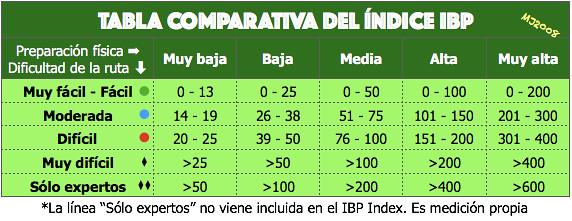
ATENCIÓN: La calificación de la ruta la hacemos en base al índice IBP para preparación muy alta y no en base a la dificultad técnica que es un dato totalmente subjetivo. Cada persona debe adaptar la calificación a su nivel/preparación según:
IBP = 174 RNG
--- INFORMACIÓN ---
Para ver la información de la carrera pincha aquí
--- ITINERARIO ---
Información obtenida de la web oficial de la carrera:
Embark on an adventure of 22km with 700m elevation gain through a course between land and sea, starting from the port of Saint-Jean-Cap-Ferrat, along the trails of the French Riviera.
Set off on a nearly complete tour of the peninsula, starting from the port of Saint-Jean-Cap-Ferrat, before climbing towards the Chapelle Saint-Michel. From there, head towards the Aire St Michel, offering a breathtaking view towards Cap Ferrat and then to Col 4 Chemins. After a beautiful passage along the Mediterranean trails, you'll descend back towards the coast. A final short climb up the Château hill will reward you with a view of the Bay of Angels before you cross the finish line on the famous Promenade des Anglais.
This semi-urban course features 50% of its route along the seaside, promising you an extraordinary experience not to be missed. It will be hard to resist taking a refreshing dip in the Mediterranean Sea once you've crossed the finish line and acquired the precious Running Stone.
--- AVITUALLAMIENTOS ---
Los puntos kilométricos son los marcados por la organización. En paréntesis según mi gps.
0 Km. St Jean Cap Ferrat
10,9 Km. Plateau St Michel (12,0 Km.)
22,3 Km. Niza (23,2 Km.)
--- COMENTARIOS ---
Carrera by UTMB con todos los detalles antes, durante y después. Carrerón.
Waypoints
 Provisioning
 0 ft
0 ft
Plateau St Michel
You can add a comment or review this trail
Comments