
Waimangu Volcanic Valley
Trail photos


Author

Trail stats
- Distance
- 2.7 mi
- Elevation gain
- 92 ft
- Technical difficulty
- Easy
- Elevation loss
- 443 ft
- Max elevation
- 1,496 ft
- TrailRank
- 30
- Min elevation
- 1,020 ft
- Trail type
- One Way
- Time
- one hour 14 minutes
- Coordinates
- 366
- Uploaded
- January 26, 2018
- Recorded
- February 2015
near Waimangu, Bay of Plenty (New Zealand)
Viewed 564 times, downloaded 30 times
Trail photos
Itinerary description
3D Video Relive:La Waimangu Volcanic Valley, un sistema geotermico nato in seguito all'eruzione del 1886 che distrusse le meravigliose Pink and White Terraces.
Per maggiori dettagli, visitate la pagina https://www.etnatracking.com/nuova-zelanda/percorsi/waimangu-volcanic-valley, dove troverete:
-Descrizione dettagliata
-Altre foto
-Informazioni sugli alloggi nei pressi del percorso.
[ENGLISH]
The Waimangu Volcanic Valley, a young geothermal system, created by the 1886 eruption that destroyed the wonderful Pink and White Terraces.
More info at https://www.etnatracking.com/en/new-zealand-travel/routes/waimangu-volcanic-valley-path:
-Detailed description
-More Pictures
-Information about accommodations next to the route.
[GERMAN]
The Waimangu Volcanic Valley, a young geothermal system, created by the 1886 eruption that destroyed the wonderful Pink and White Terraces.
Mehr Info: https://www.etnatracking.com/de/neuseeland/wanderwege-und-lehrpfade/waimangu-volcanic-valley-pfad:
-Detaillierte Beschreibung
-Mehr Bilder
-Informationen über Unterkünfte neben dem Pfad.

Waypoints
 Waypoint
 1,483 ft
Photo 1
L'inizio del percorso
 Waypoint
1,483 ft
Waypoint
1,483 ft
Photo 2
Un panorama della valle selvaggia
 Waypoint
1,417 ft
Waypoint
1,417 ft
Photo 3
Il Southern crater lake
 Waypoint
1,302 ft
Waypoint
1,302 ft
Photo 4
Frying Pan lake
 Waypoint
1,145 ft
Waypoint
1,145 ft
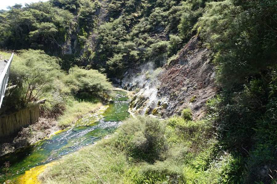
Photo 5
Torrente sulfureo in uscita dal Frying Pan lake
 Waypoint
1,181 ft
Waypoint
1,181 ft
Photo 6
Piccola sorgente geotermale
 Waypoint
1,175 ft
Waypoint
1,175 ft
Photo 7
Un torrente che esce dal Cratere Inferno
 Waypoint
1,194 ft
Waypoint
1,194 ft
Photo 8
Il bellissimo cratere Inferno
 Waypoint
1,181 ft
Waypoint
1,181 ft
Photo 9
Un geyser
 Waypoint
1,125 ft
Waypoint
1,125 ft
Photo 10
 Waypoint
1,076 ft
Waypoint
1,076 ft
Photo 11
 Waypoint
1,053 ft
Waypoint
1,053 ft
Photo 12
La Marble Terrace
 Waypoint
1,066 ft
Waypoint
1,066 ft
Photo 13
La Warbrick Terrace
 Waypoint
1,119 ft
Waypoint
1,119 ft
Photo 14
Una coppia di cigni neri
 Waypoint
1,099 ft
Waypoint
1,099 ft
Photo 15
Panorama del lago Rotomahana
 Waypoint
1,102 ft
Waypoint
1,102 ft
Photo 16
Alghe viola sull'acqua
 Waypoint
1,122 ft
Waypoint
1,122 ft
Photo 17
Un gruppo di cigni neri
 Waypoint
1,115 ft
Waypoint
1,115 ft
Photo 18
Una felce a forma di Koru, uno dei simboli della Nuova Zelanda
 Waypoint
1,115 ft
Waypoint
1,115 ft
Photo 19
Cigno nero al lago Rotomahana

You can add a comment or review this trail
Comments