
Telecabina Babele a Omu pasando por Sfinxul, Antena Costila, Crucea de Caraiman, Cabana de Caraiman
Trail photos


Author

Trail stats
- Distance
- 11.4 mi
- Elevation gain
- 3,091 ft
- Technical difficulty
- Moderate
- Elevation loss
- 3,091 ft
- Max elevation
- 7,906 ft
- TrailRank
-
92
 5
5
- Min elevation
- 6,735 ft
- Trail type
- Loop
- Time
- 7 hours 14 minutes
- Coordinates
- 2692
- Uploaded
- September 14, 2017
- Recorded
- August 2017
near Buşteni, Județul Prahova (România)
Viewed 13762 times, downloaded 340 times
Trail photos
Itinerary description
On this occasion we are going to make one of the most complete routes that can be made through the Bucegi Mountains. We will pass through the most emblematic places.
We will start from the Babele cable car and visit Sfinxul, a place where we will see very unique stones, the Peak or Varful Omu, the highest mountain in the area, the Costila antennas, and from there we will go to the Crucea de Caraiman.

To get to Babele, we have to go very early to the Busteni cable car. I managed to catch it on the third opportunity, on the other two previous occasions I had to walk up, making two other routes up the Jeppi Mare and Mici. That's why I recommend getting up early, the service begins around 7:30 in the morning.

Once on board, your trip is very enjoyable, it lasts about 13 minutes. The cost I think was about 36 leis the rise. Once I reach the Babele Gondola lift, I get ready to start this beautiful adventure through the Bucegi Mountains. The day is good, but the wind blows which makes the thermal sensation drop quite a bit. So I grab my hat and gloves and put them on.

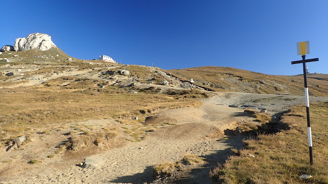
I'm going to take a path behind the cable car that takes me through Sfinxul, a place that will surprise you. There are some huge stones with very unique shapes. The one that gives its name to the area is a kind of sphinx in the style of Egypt. It is worth stopping and observing them with time.

We continue our walk now following one of the many paths that are marked by these mountains. The signposting of trails in Romania is nice. In Madrid, where I live, we are light years away from them and if there is something it is because there are volunteers who give their time to others to mark paths. THANK YOU, the administration looks the other way.
This time we follow the marks with a yellow stripe, trail No. 37 bound for Omu.
As you walk you see next to you, great valleys that open at your feet. We arrive at a crossroads, known as Saua Sugarilor. Here there is a viewpoint towards the beautiful Busteni valley. On the way back when we reach this intersection, we will continue towards Costila.
We continue and soon we will find a fork. In this place we choose the way to the left and the return we will do it to the right. We started to climb little by little. On this climb I meet two mountaineers, with whom I would later establish a friendship, from here I send you greetings Ionut and Daniela

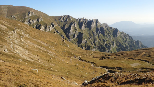
From above there are beautiful views, below me you can see the path that I will return to, it is precious. and already in the distance you can see the Omu peak and two others that are before reaching it, Gabanele and Bucura, which I will also climb.

I reach the end of the upper part and I see a hole in the mountain, where a pipe also goes down, I go down there. From here equally beautiful views, the truth that we can enjoy them from any point of the route. This place is also an out and back crossing of the route.

I go up a bit and see a small attic to my right, a kind of lookout point.
As I go up, the main track gradually gains height. I throw myself to my left to climb towards those two peaks before reaching Omu. First I go up to Gabanale, the views are beautiful from this promontory. I see a wide area. I see how they go up from the valley of Busteni a path in zetas to Omu. I'm left with the desire to be able to do it in the time I have left. So, stay tuned for the next one.

I go down a bit and climb to the next Bucura peak, where there is a cross on its top. I enjoy the views as well. I can see Omu very close, a stone's throw away. Finally I reach the top of Omu, I stay for a long time, sitting on a bench next to the cabin that is this place. It is luxurious, it gives you the sun on your face and prevents the cold air from bothering you. My friend Ionut invites me to a cup of mulled wine with cinnamon, which is great for me. We take some photos and say goodbye until the mountain brings us together again.

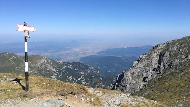
I walk a bit towards the weather station and from there towards Brasov. The views from here leave you speechless. They are to be here, to sit and let you go towards the horizon of the mountains.
I retrace my steps towards Cabana Omu and now I'm going down the easy and more comfortable path. The air begins to subside a bit and you enjoy the beauty of looking where you walk.

Arriving at the trail junction, which we reached by going down the pipe. Now we take the path on the left, it is wonderful. The path is narrow but without problems.

We now arrive at the Saua Sugarilor area and as I said before. Now we will take the path with a red cross that takes us to the antennas of Costila. This path reaches the track that climbs to the very top. It's time for lunch and I choose an area behind him with a view of Busteni. You certainly couldn't pick a better place to eat. I stay a good while, and enjoy its views.

I finish eating, I try to turn the antennas completely. There is a slightly worse bit, but it is possible. I go down a little cross-country until I join the path that will take me to Crucea de Caraiman. On my way I see a couple of people who are painting the signage to whom I say THANK YOU.

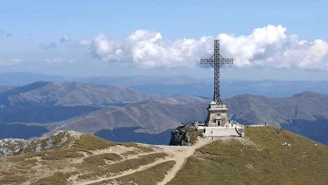
From the top of Pico de Caraiman, you can see the Crucea de Caraiman in the background. Very nice views from the top and as you go down you see it closer and closer. It is a very charming place, it is seen how many people approach the great Cross erected in this place in commemoration of the fallen in the First World War.
I had already been to this place following this route. There are amazing views from here, below us we have Busteni, but we can also see other nearby towns.

The afternoon begins to fall and the evening light illuminates the path that I am going to take back. Normally people go up a slightly wider path that takes them directly to the Babele cable car. I still have time and I would like to repeat the passage through this other path that I climbed coming by Jeppi Mici. It is a much narrower path where you will sometimes have aerial views and the occasional cable to help you. But it can be done without problems. I had my one, the second time it happened and I did very well on the way down.

Downstairs I see Cabana Caraiman waiting for me. From here I will go up to the Babele cable car following a perfectly marked route. The meadows and streams follow one another. I already see my destiny in the background, despite the hardness of the route, I am super happy for what I have enjoyed with it.
I wish you enjoy with it.
Video of the route
Transport We went up in the cable car from Busteni to Babele. We also do the return by cable car.
Recommended season Spring, Summer, Autumn.
statistics
Difficulty level: Very hard
Distance: 18.4km
Unevenness + 847 meters Unevenness - 779 meters
Total time: 7h 14'
Moving time: 5h 14'
Standing time: 2h
Overall average speed: 2.55km/h
Average moving speed: 3.53 km/h
Total average pace per km: 23:41 min/km
Average moving pace per km: 14:39 min/km
IBP Index: 114 Report

Other routes in the area
We will start from the Babele cable car and visit Sfinxul, a place where we will see very unique stones, the Peak or Varful Omu, the highest mountain in the area, the Costila antennas, and from there we will go to the Crucea de Caraiman.

To get to Babele, we have to go very early to the Busteni cable car. I managed to catch it on the third opportunity, on the other two previous occasions I had to walk up, making two other routes up the Jeppi Mare and Mici. That's why I recommend getting up early, the service begins around 7:30 in the morning.

Once on board, your trip is very enjoyable, it lasts about 13 minutes. The cost I think was about 36 leis the rise. Once I reach the Babele Gondola lift, I get ready to start this beautiful adventure through the Bucegi Mountains. The day is good, but the wind blows which makes the thermal sensation drop quite a bit. So I grab my hat and gloves and put them on.

I'm going to take a path behind the cable car that takes me through Sfinxul, a place that will surprise you. There are some huge stones with very unique shapes. The one that gives its name to the area is a kind of sphinx in the style of Egypt. It is worth stopping and observing them with time.

We continue our walk now following one of the many paths that are marked by these mountains. The signposting of trails in Romania is nice. In Madrid, where I live, we are light years away from them and if there is something it is because there are volunteers who give their time to others to mark paths. THANK YOU, the administration looks the other way.
This time we follow the marks with a yellow stripe, trail No. 37 bound for Omu.

As you walk you see next to you, great valleys that open at your feet. We arrive at a crossroads, known as Saua Sugarilor. Here there is a viewpoint towards the beautiful Busteni valley. On the way back when we reach this intersection, we will continue towards Costila.

We continue and soon we will find a fork. In this place we choose the way to the left and the return we will do it to the right. We started to climb little by little. On this climb I meet two mountaineers, with whom I would later establish a friendship, from here I send you greetings Ionut and Daniela

From above there are beautiful views, below me you can see the path that I will return to, it is precious. and already in the distance you can see the Omu peak and two others that are before reaching it, Gabanele and Bucura, which I will also climb.

I reach the end of the upper part and I see a hole in the mountain, where a pipe also goes down, I go down there. From here equally beautiful views, the truth that we can enjoy them from any point of the route. This place is also an out and back crossing of the route.

I go up a bit and see a small attic to my right, a kind of lookout point.
As I go up, the main track gradually gains height. I throw myself to my left to climb towards those two peaks before reaching Omu. First I go up to Gabanale, the views are beautiful from this promontory. I see a wide area. I see how they go up from the valley of Busteni a path in zetas to Omu. I'm left with the desire to be able to do it in the time I have left. So, stay tuned for the next one.

I go down a bit and climb to the next Bucura peak, where there is a cross on its top. I enjoy the views as well. I can see Omu very close, a stone's throw away. Finally I reach the top of Omu, I stay for a long time, sitting on a bench next to the cabin that is this place. It is luxurious, it gives you the sun on your face and prevents the cold air from bothering you. My friend Ionut invites me to a cup of mulled wine with cinnamon, which is great for me. We take some photos and say goodbye until the mountain brings us together again.

I walk a bit towards the weather station and from there towards Brasov. The views from here leave you speechless. They are to be here, to sit and let you go towards the horizon of the mountains.

I retrace my steps towards Cabana Omu and now I'm going down the easy and more comfortable path. The air begins to subside a bit and you enjoy the beauty of looking where you walk.

Arriving at the trail junction, which we reached by going down the pipe. Now we take the path on the left, it is wonderful. The path is narrow but without problems.

We now arrive at the Saua Sugarilor area and as I said before. Now we will take the path with a red cross that takes us to the antennas of Costila. This path reaches the track that climbs to the very top. It's time for lunch and I choose an area behind him with a view of Busteni. You certainly couldn't pick a better place to eat. I stay a good while, and enjoy its views.

I finish eating, I try to turn the antennas completely. There is a slightly worse bit, but it is possible. I go down a little cross-country until I join the path that will take me to Crucea de Caraiman. On my way I see a couple of people who are painting the signage to whom I say THANK YOU.

From the top of Pico de Caraiman, you can see the Crucea de Caraiman in the background. Very nice views from the top and as you go down you see it closer and closer. It is a very charming place, it is seen how many people approach the great Cross erected in this place in commemoration of the fallen in the First World War.

I had already been to this place following this route. There are amazing views from here, below us we have Busteni, but we can also see other nearby towns.

The afternoon begins to fall and the evening light illuminates the path that I am going to take back. Normally people go up a slightly wider path that takes them directly to the Babele cable car. I still have time and I would like to repeat the passage through this other path that I climbed coming by Jeppi Mici. It is a much narrower path where you will sometimes have aerial views and the occasional cable to help you. But it can be done without problems. I had my one, the second time it happened and I did very well on the way down.

Downstairs I see Cabana Caraiman waiting for me. From here I will go up to the Babele cable car following a perfectly marked route. The meadows and streams follow one another. I already see my destiny in the background, despite the hardness of the route, I am super happy for what I have enjoyed with it.
I wish you enjoy with it.
Video of the route
Transport We went up in the cable car from Busteni to Babele. We also do the return by cable car.
Recommended season Spring, Summer, Autumn.
statistics
Difficulty level: Very hard
Distance: 18.4km
Unevenness + 847 meters Unevenness - 779 meters
Total time: 7h 14'
Moving time: 5h 14'
Standing time: 2h
Overall average speed: 2.55km/h
Average moving speed: 3.53 km/h
Total average pace per km: 23:41 min/km
Average moving pace per km: 14:39 min/km
IBP Index: 114 Report
Other routes in the area
Waypoints


 Mountain hut
 0 ft
0 ft
Cabana Babele


 Summit
0 ft
Summit
0 ft
Caraiman


 Intersection
0 ft
Intersection
0 ft
Cruce de senderos 12:37:58
Tomar Cruz Roja
Intersection
6,978 ft
Cruce de Senderos 08:38:18
Intersection
7,431 ft
Cruce de senderos 09:54:55
Intersection
7,552 ft
Cruce de senderos 12:55:07


 Intersection
7,415 ft
Intersection
7,415 ft
Ida por la Izquierda 09:22:19
 Panorama
7,270 ft
Panorama
7,270 ft
Mirador 09:15:02
Panorama
7,605 ft
Mirador 09:30:01
Panorama
7,848 ft
Mirador 11:39:31
Panorama
7,444 ft
Mirador 12:09:30


 Information point
7,535 ft
Information point
7,535 ft
Pista 12:52:10
Intersection
0 ft
Regreso por la izquierda
Intersection
7,579 ft
Regreso por la izquierda13:55:12


 Intersection
7,464 ft
Intersection
7,464 ft
Subida por la izquierda 09:56:18

Comments (8)
You can add a comment or review this trail
Esta zona parece más agreste y también bonita, no habrás subido por esa senda que se ve en el vídeo?😅
Hay Roman, con las ganas me he quedado de subirla. La tengo ya pendiente para la próxima vez, me llamo muchisimo la atención. La ruta es una pasada. recorres los lugurés más emblemáticos de la zona en una sola ruta. Un abrazo.
Hola genial descripción. me la apunto para mi hacerla esta primavera.
Quisiera ir desde Cota 2000 hasta Bran en varios días, e intentaré seguir la ruta que hiciste a la vuelta , para llegar a Omu.
Como son varios días, sabes si hay problema para coger agua?
GRacias
HOla Lo mejor está por llegar, en esa época del año no creo que haya problemas de agua, y seguramente te vas a encontrar con algo de nieve. Es una buena ruta la que vas a realizar y te va a encantar. Yo este año, volveré a subir a Omu desde Busteni.
Ya me contarás que tal tu experiencia, deseo que sea positiva y ten cuidado con el tema de los Osos. Saludos antonio.
I have followed this trail verified View more
Information
Easy to follow
Scenery
Moderate
Gracias por la aportación de la ruta!!! Es muy bonita. La acabo de hacer y me ha servido de mucho tu track. Todo detallado a la perfección.
La última parte, desde la Cruz de Caraiman hasta el teleférico, la he hecho por el recorrido más convencional, ya que el techo de nubes estaba bajo y no se veía muy bien esa zona. Por precaución y porque iba sólo. Lo demás ruta sencilla, bonita aunque larga. Pero no desmerece nada.
Hola arimagorria, me alegro que te haya gustado la ruta. Es cierto que si no hay visibilidad la vuelta por el sendero mas expuesto puede tener su peligro. Gracias por tu comentario y valoración saludos antonio.
I have followed this trail View more
Information
Easy to follow
Scenery
Moderate
Impresionant ruta amb bons paisatges. Molt recomanable.
Hola JORDI BALLESTER DE BELLESTAR, gracias por tu comentario y valoración saludos Antonio.