
New Zealand - Tongariro National Park
Trail photos


Author

Trail stats
- Distance
- 10.76 mi
- Elevation gain
- 2,480 ft
- Technical difficulty
- Moderate
- Elevation loss
- 2,480 ft
- Max elevation
- 6,149 ft
- TrailRank
- 61
- Min elevation
- 3,687 ft
- Trail type
- Loop
- Time
- 5 hours 30 minutes
- Coordinates
- 1995
- Uploaded
- December 28, 2015
- Recorded
- November 2015
near Whakapapa Village, Manawatu-Wanganui (New Zealand)
Viewed 2708 times, downloaded 111 times
Trail photos
Itinerary description
Link to the blog post - Link to the blog page
Track Description / Characteristics of the Route:
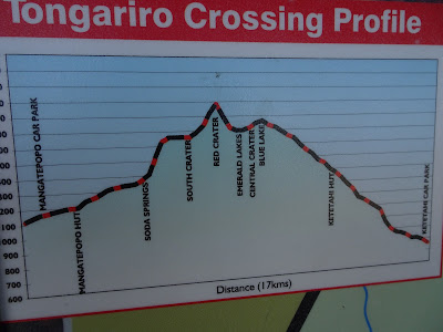
Distance / Distance: 17.3km
Elevation Gain / Ascent: 758m
Max / Min Altitude: 1124m / 1874m
Difficulty / Difficulty: Medium / Medium
Alpine Grade: SD (Without difficulty)
Alpine Grade: SD (Without difficulty)
Activity: Hiking / Hiking
Recommended Cartography / Recommended Cartography:
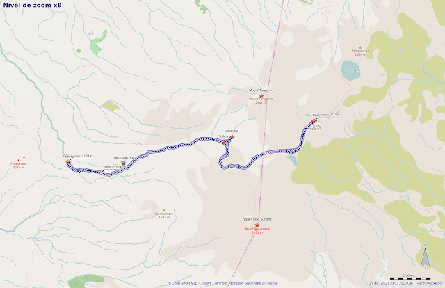
The Tongariro National Park was the first National Park to be recognized in New Zealand, and one of the first in the world. Declared a cultural and natural heritage, it houses three active volcanoes, the Ruapehu, Tongariro and Ngauruhoe. Also, inside the Park we have one of the most popular multi-day cruises in New Zealand, the Tongariro Alpine Crossing.
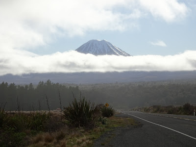
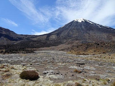
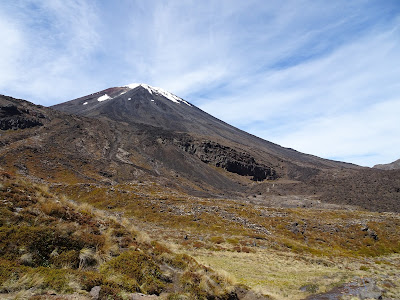
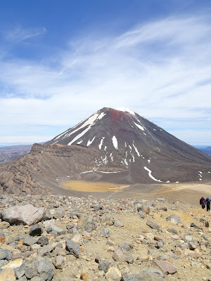
Mount Ngauruhoe has a great prominence, and stands on the plains of the North Island, being able to see from a distance. The shape of the stratovolcano irrevocably reminds us of Mount Fuji.

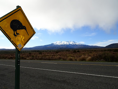
A little further south, we find Monte Ruapehu, which is much more snowbound because it has more height. In fact, there is still a glacier in its crater.
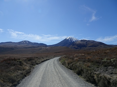
The way to enter the NP and ascend to the Tongariro is marked as Mangatepopo Hut, a mountain refuge that can be used (under reservation) to make the Tongariro Alpine Crossing. After leaving State Highway 47, we take an unpaved trail of about 7km until we reach the parking lot. The parking is not too big for the amount of tourists that visit it, so it is recommended to arrive soon.
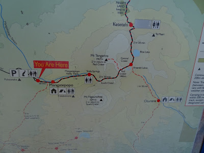
Next to the parking we have some services and a plan to do the Tongariro Alpine Crossing. As we do not have time to do the whole trip, we will go up to the Red Crater, from we can enjoy the best views of the Tongariro Alpine Crossing, being the highest point of the route.
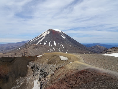
The majestic conical shape of the Ngauruhoe is present throughout the tour.
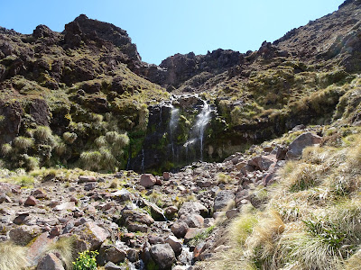
Just before starting the climb up the slopes of the stratovolcano, we diverted slightly to visit Soda Springs, small waterfalls that contrast with the dryness of the Martian landscape (volcanic) traveled so far. Together with them we also have public services.
The climb up to the plain between the Ngauruhoe and the Tongariro is done by a road conditioned with stairs, which helps us to save the high unevenness.
In the plain seasonal lakes are usually formed, but they dry quickly with the arrival of summer, between the heat and the porosity of the volcanic soil.
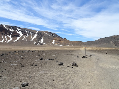
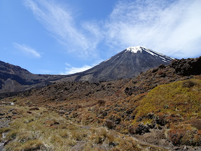
After crossing the plain, flanked by the Tongariro and the Ngauruhoe, we have a steep climb to the Red Crater.
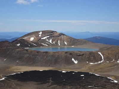
But the views from above compensate for the effort. In the background we can see the Blue Lake, another lake formed in an old crater.
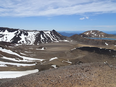
Below the Red Crater we have other small lakes of striking colors.
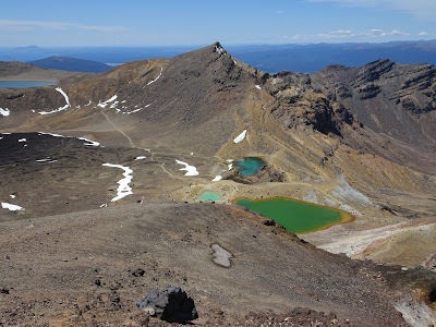
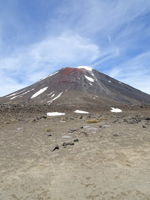
And finally the Red Crater, a crater that erupted uncovered its walls with somewhat capricious colors.

Once we have rested on the heights of the Red Crater, we descend the path we have used for the ascent. The excursion can perfectly be complemented with the ascent to the Tongariro (from the Red Crater) or to the Ngauruhoe (from the plain). However, since we did not have winter equipment, and there was still enough snow on the peaks, we decided to return to the parking lot, with our 17km behind us and the views we had had were enough for the day.
Summary:
- Visit to simplified one of the oldest natural parks in New Zealand. Within all possible ascents in the northern part of the parking lot, this may be the one that requires less effort while we can enjoy spectacular views. If we have time, strength, and conditions are good, it can be complemented with the climbs to Ngauruhoe and Tongariro.
- If we also have several days, we can make the Tongariro Alpine Crossing, a two day trip using the mountain huts to spend the night.
- There is no drinking water in the entire route, and given the volcanic nature of the landscape, in the middle of summer it is advisable to hydrate well.
- Given that it is one of the most frequented parks, it is recommended to arrive early in high season so as not to have parking problems.
Track Description / Characteristics of the Route:
Distance / Distance: 17.3km
Elevation Gain / Ascent: 758m
Max / Min Altitude: 1124m / 1874m
Difficulty / Difficulty: Medium / Medium
Alpine Grade: SD (Without difficulty)
Alpine Grade: SD (Without difficulty)
Activity: Hiking / Hiking
Recommended Cartography / Recommended Cartography:
The Tongariro National Park was the first National Park to be recognized in New Zealand, and one of the first in the world. Declared a cultural and natural heritage, it houses three active volcanoes, the Ruapehu, Tongariro and Ngauruhoe. Also, inside the Park we have one of the most popular multi-day cruises in New Zealand, the Tongariro Alpine Crossing.
Mount Ngauruhoe has a great prominence, and stands on the plains of the North Island, being able to see from a distance. The shape of the stratovolcano irrevocably reminds us of Mount Fuji.
A little further south, we find Monte Ruapehu, which is much more snowbound because it has more height. In fact, there is still a glacier in its crater.
The way to enter the NP and ascend to the Tongariro is marked as Mangatepopo Hut, a mountain refuge that can be used (under reservation) to make the Tongariro Alpine Crossing. After leaving State Highway 47, we take an unpaved trail of about 7km until we reach the parking lot. The parking is not too big for the amount of tourists that visit it, so it is recommended to arrive soon.
Next to the parking we have some services and a plan to do the Tongariro Alpine Crossing. As we do not have time to do the whole trip, we will go up to the Red Crater, from we can enjoy the best views of the Tongariro Alpine Crossing, being the highest point of the route.
The majestic conical shape of the Ngauruhoe is present throughout the tour.
Just before starting the climb up the slopes of the stratovolcano, we diverted slightly to visit Soda Springs, small waterfalls that contrast with the dryness of the Martian landscape (volcanic) traveled so far. Together with them we also have public services.
The climb up to the plain between the Ngauruhoe and the Tongariro is done by a road conditioned with stairs, which helps us to save the high unevenness.
In the plain seasonal lakes are usually formed, but they dry quickly with the arrival of summer, between the heat and the porosity of the volcanic soil.
After crossing the plain, flanked by the Tongariro and the Ngauruhoe, we have a steep climb to the Red Crater.
But the views from above compensate for the effort. In the background we can see the Blue Lake, another lake formed in an old crater.
Below the Red Crater we have other small lakes of striking colors.
And finally the Red Crater, a crater that erupted uncovered its walls with somewhat capricious colors.
Once we have rested on the heights of the Red Crater, we descend the path we have used for the ascent. The excursion can perfectly be complemented with the ascent to the Tongariro (from the Red Crater) or to the Ngauruhoe (from the plain). However, since we did not have winter equipment, and there was still enough snow on the peaks, we decided to return to the parking lot, with our 17km behind us and the views we had had were enough for the day.
Summary:
- Visit to simplified one of the oldest natural parks in New Zealand. Within all possible ascents in the northern part of the parking lot, this may be the one that requires less effort while we can enjoy spectacular views. If we have time, strength, and conditions are good, it can be complemented with the climbs to Ngauruhoe and Tongariro.
- If we also have several days, we can make the Tongariro Alpine Crossing, a two day trip using the mountain huts to spend the night.
- There is no drinking water in the entire route, and given the volcanic nature of the landscape, in the middle of summer it is advisable to hydrate well.
- Given that it is one of the most frequented parks, it is recommended to arrive early in high season so as not to have parking problems.

Waypoints
 Summit
 Mountain hut
 0 ft
0 ft
Mountain Hut


 Car park


 Waypoint
0 ft
Waypoint
0 ft
Toilets
 Waterfall
You can add a comment or review this trail
Comments