
New Zealand - Lake Okataina
Trail photos


Author

Trail stats
- Distance
- 7.81 mi
- Elevation gain
- 1,184 ft
- Technical difficulty
- Moderate
- Elevation loss
- 1,184 ft
- Max elevation
- 1,671 ft
- TrailRank
- 32
- Min elevation
- 1,295 ft
- Trail type
- Loop
- Time
- 3 hours 15 minutes
- Coordinates
- 190
- Uploaded
- January 1, 2016
- Recorded
- November 2015
near Tikitere, Bay of Plenty (New Zealand)
Viewed 596 times, downloaded 17 times
Trail photos
Itinerary description
Link to the blog post - Link to the blog page
Track Description / Characteristics of the Route:
Distance / Distance: 12.60 km
Elevation Gain / Ascent: 363m
Max / Min Altitude: 509m / 395m
Difficulty / Difficulty: Easy / Easy
Alpine Grade: SD (Without difficulty)
Alpine Grade: SD (Without difficulty)
Activity: Hiking / Hiking
Recommended Cartography / Recommended Cartography:
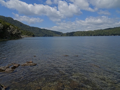
Beginning our Neo Zeland adventure on the North Island, one of the mandatory stops is the Bay of Plenty and the Rotorua area. Lake Okataina has many possibilities, from hiking for several days and excursions of a few hours, to mountain biking, canoeing and fishing.
Next to the parking we have a hotel, bar / restaurant as well as public toilets. I do not remember if free camping is allowed in this place, but without a doubt, spending a night on the shores of the lake should be a wonderful experience.
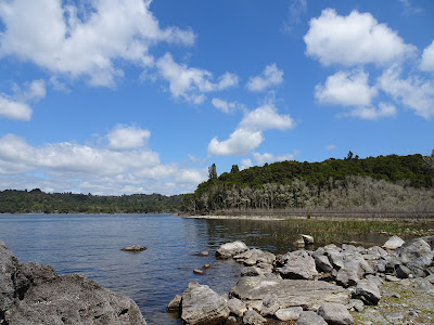
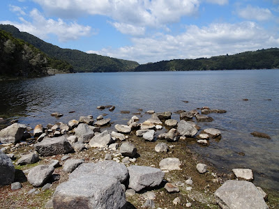
We walk along the path that runs along the shore of the lake. The trail goes to the camping area of Lake Tarawera, but we shorten the activity by a 4-hour walk back and forth. Enough to capture the beauty of the place.
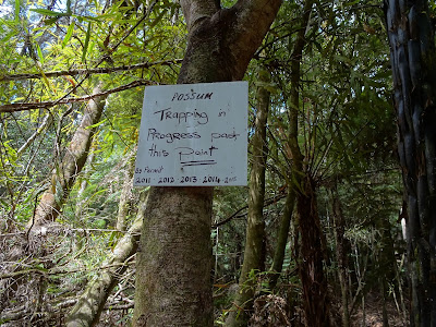
The forest, like many other areas of New Zealand, is full of possum traps, in order to combat the invasive species that is killing a lot of local wildlife, especially Kiwis and Keas.
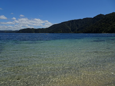
Back to the parking lot, with the light of noon, the waters of the lake remind me of exotic Caribbean beaches.

Summary:
- Easy activity, well marked road, we can find a couple of beaches on the road in case we want to refresh.
- There is no water during the whole journey, so it is important to take it.
- I recommend visiting the DOC website to have more information about the number of activities and commercial operators in the area.
Track Description / Characteristics of the Route:
Distance / Distance: 12.60 km
Elevation Gain / Ascent: 363m
Max / Min Altitude: 509m / 395m
Difficulty / Difficulty: Easy / Easy
Alpine Grade: SD (Without difficulty)
Alpine Grade: SD (Without difficulty)
Activity: Hiking / Hiking
Recommended Cartography / Recommended Cartography:
Beginning our Neo Zeland adventure on the North Island, one of the mandatory stops is the Bay of Plenty and the Rotorua area. Lake Okataina has many possibilities, from hiking for several days and excursions of a few hours, to mountain biking, canoeing and fishing.
Next to the parking we have a hotel, bar / restaurant as well as public toilets. I do not remember if free camping is allowed in this place, but without a doubt, spending a night on the shores of the lake should be a wonderful experience.
We walk along the path that runs along the shore of the lake. The trail goes to the camping area of Lake Tarawera, but we shorten the activity by a 4-hour walk back and forth. Enough to capture the beauty of the place.
The forest, like many other areas of New Zealand, is full of possum traps, in order to combat the invasive species that is killing a lot of local wildlife, especially Kiwis and Keas.
Back to the parking lot, with the light of noon, the waters of the lake remind me of exotic Caribbean beaches.
Summary:
- Easy activity, well marked road, we can find a couple of beaches on the road in case we want to refresh.
- There is no water during the whole journey, so it is important to take it.
- I recommend visiting the DOC website to have more information about the number of activities and commercial operators in the area.
Waypoints
 Car park
 0 ft
0 ft
Parking
You can add a comment or review this trail
Comments