
Monument Valley - Wildcat Trail
Trail photos


Author

Trail stats
- Distance
- 3.89 mi
- Elevation gain
- 374 ft
- Technical difficulty
- Easy
- Elevation loss
- 374 ft
- Max elevation
- 5,607 ft
- TrailRank
- 53
- Min elevation
- 5,236 ft
- Trail type
- Loop
- Time
- 58 minutes
- Coordinates
- 437
- Uploaded
- November 6, 2023
- Recorded
- October 2023
near Oljato-Monument Valley, Arizona (United States)
Viewed 36 times, downloaded 5 times
Trail photos
Itinerary description
Description:
The Wildcat Trail leads us to the famous Mitten Buttes and Merrick Butte. At some point you will find yourself surrounded by these towering formations and the stunning Monument Valley landscape. The 6' 7 km trail is well marked and signposted. It is not a technically difficult trail, although the sandy parts can slow down the walk.
The trail begins to the left of the parking area, we will find the marked beginning. We will have to travel the first kilometer on the way there and back, after 1.1 km keep to the right to begin the circular part of the trail. The path to the left is the return.
Although the park is open year-round, the best season to hike this trail is spring (April to June) and fall (September and October), when temperatures are moderate and the weather is more pleasant.
Fountain:
Monument Valley
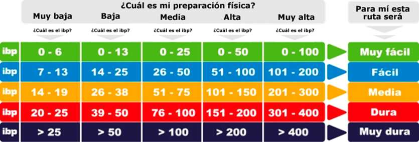
Route Difficulty: IBP Index: 35
IBP Index is an automatic rating system that rates the difficulty of a route traveled, so that we can compare different routes.
Important, do not confuse the degree of difficulty of a route with the effort it will cost us to carry it out: an IBP index of 60 will be a very hard route for an uninitiated person, normal for someone with a medium preparation and very easy for a professional. (see comparative scale)
Tips
Better accompanied, avoid going alone, inform about the activity you are going to do (estimated time, itinerary, etc.), choose the activity to do well taking into account your physical preparation and knowledge.
Plan your excursion: use maps, books, guides, etc., if you lack experience, go to mountain clubs or experienced people to advise you...
Check the weather report the days before the activity to be carried out and before leaving.
Never be in a hurry, the important thing is to take care of our strength and reach the goal set, in any case, we must know how to give up, prudence is a plus, the mountains are always there to return another day.
Take care of your physical preparation during the week.
Bring light and energetic food, as well as enough drink so that at the end of the route, you still have leftovers.
Clothing and footwear should be appropriate for hiking.
Carry enough food and water, some clothing, a first aid kit, sunscreen, a hat, and a headlamp in your backpack.
A charged mobile phone and having an external battery is essential. In the event of an accident, the warning can be very quick.
Remember, prudence is a virtue, not a weakness.
Important Warning
All information and data on the activities published here are merely descriptive of a mountain activity or a route carried out by me and/or a group of friends, on a specific day and conditions.
Both the text, as well as the personal opinions presented, itineraries, reviews, information, maps, tracks, photos and any other published material of the route, can be used freely as help or reference, but certainly not as a guide that must be followed. Therefore, the performance of the activity is under the sole responsibility of the user.
That is, everything published is based on my experience or personal appreciation of what I have seen, experienced and done. What is valid for me, due to my abilities, knowledge, previous experience or tastes, may not be valid or may not coincide with the tastes of other people.
In no case, I am responsible for the consequences that poor sports practice could cause. Remember that no matter how easy one of these activities is in the natural environment, it always entails risks that the practitioner must assume and be aware of, being ultimately responsible for the actions undertaken.
If you do not have sufficient knowledge to carry out these activities with guarantees, it is advisable to register in a club that carries out this type of activities or training courses, such as Union Montañera Pataguanche .
Everyone can enjoy the natural environment in their own way, but with responsibility.
Points of information and interests:
Waypoints
 Information point
 0 ft
0 ft


001 Inicio Sendero
At the beginning you must indicate the time and number of people on the control sheet
 Photo
Photo


 Intersection
0 ft
Intersection
0 ft


003 Bifurcación a la derecha
Tomamos el sendero de la derecha, el se la izquierda es de regreso


 Panorama


You can add a comment or review this trail
Comments