ETAPA 4 NAMCHE BAZAR (3440M) - PHORTSE TENGA (3575M)
near Namche Bazar, Eastern Region (Nepal)
Viewed 1192 times, downloaded 104 times
Trail photos


STAGE 4 NAMCHE BAZAR (3450M) -
PHORTSE TENGA (3575M)
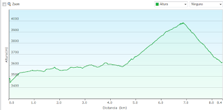
Kilometers: 8.3 KM
Total Time: 03:50 hours. Moving time 2:47
hours.
Maximum Height: 3975 meters, height
Minimum: 3448 meters.
Cumulative elevation gain:
651meters
Cumulative gradient of descent: 508
meters
Download the route in Wikiloc
Profile:

We continue the circuit of trekking and start the march towards Phortse,
We start the day with a steep climb until we reach Mon la Pass (3972
m). We leave the pleasant town of Namche and start the intense climb
from the previous day to a small village. From here we continue on a path
in front that moves us away from this area.
We started a constant climb along a very well defined path.
Curiously we find an old man who collects money for the
maintenance and the construction work of this road.
We will arrive at a beautiful forest of rhododendrons where we have a crossing.
From this point the circular route begins.
To the right we would continue
towards the monastery of Tengboche and in our case we continue for a small
path that ascends through a pleasant forest that takes us to the small village of Mon la Pass. A
step located at almost four thousand meters. Where we take the opportunity to rest and
Enjoy the breathtaking views.
Curiously, as soon as we reach the highest point we find the step
of a race, we think it's the Everest marathon. It costs us
walk and make these rises to think about running. Is something
Awesome.
As usual, we stopped at a lodge to have a ginger tea and
Rest for a while.
On this tour we find a great influx of people and
porters Now we have to go down to Phortse following the path that leads us
in important descent to the lodge
where we are going to spend the night. They suppose about 25 minutes of pleasant descent.
The participants of the race who have to climb can not say the same thing
This strong port and many of them are very disadvantaged.
As a curiosity we were able to enjoy the partridges or pheasants of
the area, that the males have a very striking color.
The lodge is correct, we were able to enjoy a shower
Hot, although the bathroom was quite seedy. Today's day has been quite short and we have
used to wash clothes and groom a little.
The shower cost us 500 rupis. Water 200 rupis and charge batteries 400
rupees.
This site is located very close to the river
Dudh Coshi Nadi and certainly the population is very small, we will find
two or three hostels and little else.
The largest village is Portse, located half an hour with a steep climb.
This is a good option to take a walk in the afternoon. This day we have
enough time to take a break. In our case we have approached the river
and a little more. We have to save our strength for everything that we have left and we are not to waste.
for more information click on the link.
Waypoints
 Waypoint
 0 ft
0 ft
MIRADOR VISTA VALLE41
 Panorama
 11,677 ft
MUSEO EVEREST Y VISTAS LHOTSE Y AMADABLAN41
 Waypoint
 0 ft
0 ft
Namche Bazaar(3440m)31
Namche Bazaar(3440m)
 Waypoint
 11,895 ft
PHORTSE TENGA41
Comments (3)
You can add a comment or review this trail


I have followed this trail View more
Information
Easy to follow
Scenery
Difficult
Una etapa de continuació seguint l'itinerari marcat. Sense dificultats. Els dies assolellats i sense vent;les nits ja molt fredes.Gaudint del paisatge a cada moment.
Lugares preciosos para recordar
I have followed this trail View more
Information
Easy to follow
Scenery
Moderate
Etapa curta però la altitud comença a notar-se i hem d'anar amb compte de no córrer,i mestrestant disfrutar del paisatge bucòlic que ens envolta.