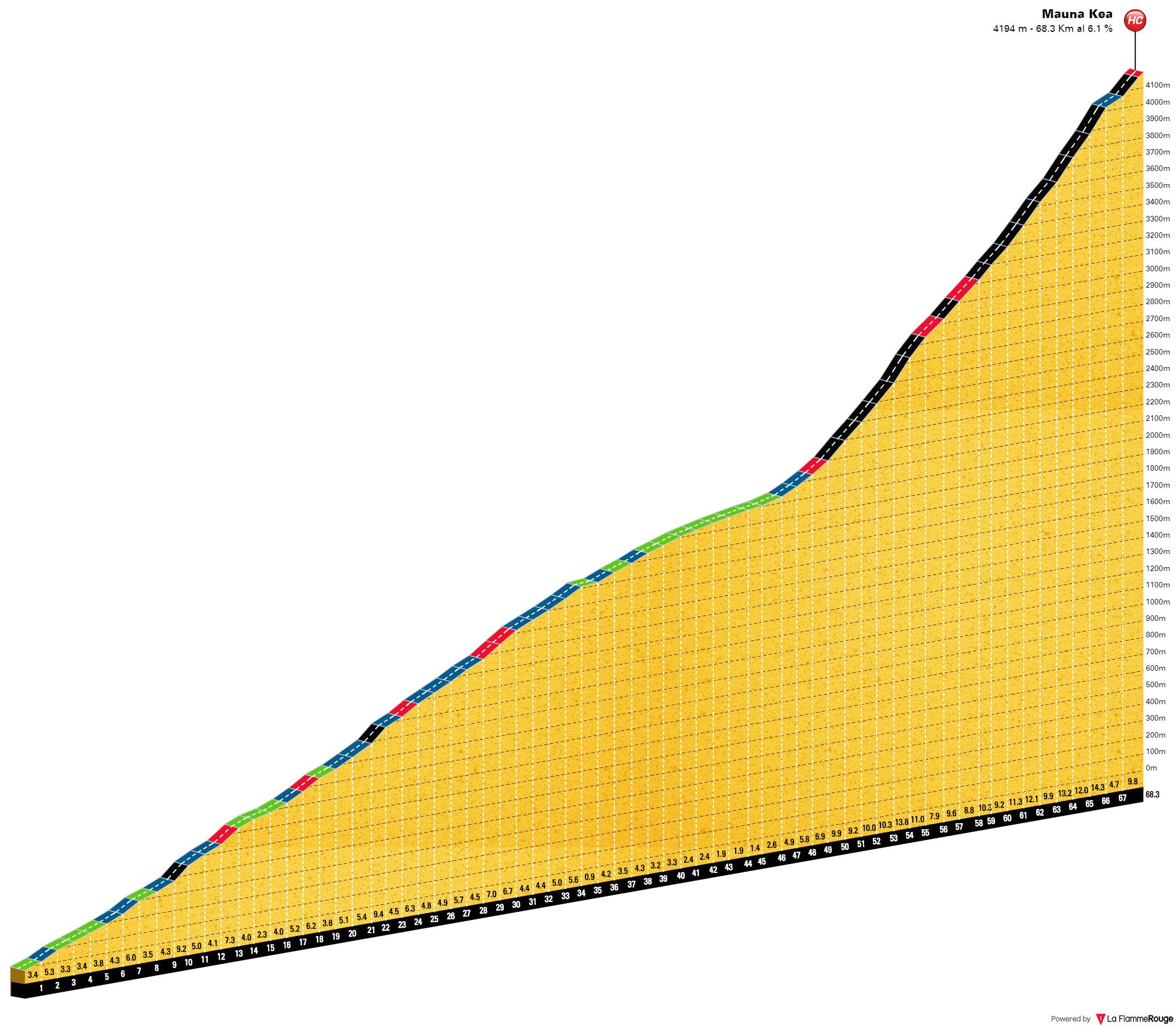
 Ascension du Mauna Kea depuis Hilo, et du Mauna Loa (jusqu'à l'observatoire) dans la foulée, avant de redescendre de l'autre côté de Big Island (Waikōloa beach) Fait avec le gravel de Bob: une partie de la montée du Mauna Kea se fait sur piste, tout le reste étant asphalté
  Préambule
: Il ne fait pas encore jour, 🌙 mais c'est bien le grand jour: on est au pied de la bête! La veille, on a laissé une voiture au
Visitor Center avec les vélos de rechange (pour ceux qui utiliseront un VTT sur la section de piste), quelques réserves d'eau et de nourriture, vêtements et autres accessoires. Lever avant l'aube, et départ au pied de l'énorme
figuier des banians du parking du Reeds Bay Hotel (la taille gigantesque de cet arbre semble suggérer qu'il apprécie le climat humide d'Hilo, ce qui n'est pas forcément le cas des cyclistes). Espérons que ma préparation
hispano-
californienne s'avérera suffisante pour dompter le monumental Mauna Kea, deuxième sommet du globe en termes de "
prominence sèche" (même si, je vous l'accorde, nous ne démarrerons pas depuis les profondeurs abyssales du Pacifique). Une pensée pour l'unique volcan que j'ai gravi jusqu'ici, le
Puy de Dôme, avant d'essayer de passer à la catégorie supérieure! Le peloton du jour est composé de 5 cyclistes: John, Clarence, Sam, Luke et moi-même (Chris et sa femme nous attendront en voiture à différents endroits).
🏁 L'idée consiste tout d'abord à pédaler jusqu'à la pancarte "Mile 0" de la
Saddle road (Hawaii route 200) en longeant la côte sur 3km, avant que le soleil n'émerge de l'horizon, pour prendre quelques photos de groupe. Précisons au passage que je consens
exceptionnellement à utiliser ces machiavéliques et anachroniques unités impériales, d'une part en raison de la facilité de conversion d'un kilométrage nul, et d'autre part par respect à l'égard de cette pancarte symbolique. Il y a par ailleurs une petite plage de sable volcanique, au pied du modeste
phare de Coconut Point, qui nous permet de tremper ("dip") symboliquement une roue dans l'océan avant d'attaquer véritablement la montée. Par chance, le soleil pointe son nez entre les nuages, 🌅 et le timing est parfait!
C'est parti! Un peu nerveux, je suis convaincu d'avoir paumé mes lunettes de vue dans la précipitation du départ... mais en fait tout va bien. 😊 Clarence nous fausse rapidement compagnie, pressé d'en découdre avec le chronomètre, mais le reste de la troupe préfère plutôt jouer la carte de la prudence, et reste plus ou moins groupé. On récupère la grosse route au bout de 17km: on va alors rouler pendant un bon moment sur sa large bande d'arrêt d'urgence. Attention: tout est plus grand aux USA, et les encoches de l'horrible bande rugueuse qui nous sépare des voies principales ne font pas exception, si profondes qu'il faudra prendre soin d'éviter de rouler dessus (on va en reparler!). La première partie de l'ascension se fera sous la pluie, ou plutôt dans la bruine (un "crachin hawaïen" ☔️ qui explique la végétation plutôt luxuriante), jusqu'à ce qu'on émerge au-dessus des nuages vers 1000m d'altitude (rien de surprenant: John, qui a déjà gravi cette montagne à plusieurs reprises, nous avait mis en garde contre l'abondante pluviométrie de la côte au vent), mais la température reste agréable. Il faudra même faire une pause pour mettre de la crème, puisque le soleil grimpe rapidement dans le ciel et que l'altitude ne va pas atténuer l'ardeur de ses rayons, sachant qu'il n'y aura aucune ombre pour nous protéger 🌞 (malgré le maillot, on cramera tous un petit peu au niveau des épaules: certaines parties du joli maillot que John avait fait faire spécialement pour l'occasion n'étaient vraisemblablement pas suffisamment "UV-proof" pour les altitudes élevées qui nous attendent!). La végétation devient peu à peu plus aride. On prend notre temps (il s'agit d'économiser ses forces pour la partie finale) pour arriver au niveau du Pu'u Huluhulu ("colline chevelue" en hawaïen), cône volcanique broussailleux situé au pied des routes d'accès vers les deux gros volcans.
En effet, au bout de 48km, à peine quelques centaines de mètres après avoir ignoré la bifurcation de gauche (route du Mauna Loa), on prend celle de droite, pour le Mauna Kea. Il reste quelques traces des récentes
manifestations contre la construction du
TMT (Thirty Meter Telecope). C'est à partir de cette
intersection de la Saddle road (2005m), que les choses vont se corser sérieusement: la pente ne tarde pas à s'accentuer, c'est même parfois méchamment raide, mais le paysage en vaut la peine: d'un côté, on est surplombé par les cimes abruptes du Mauna Kea, et de l'autre, la silhouette imposante du Mauna Loa domine le paysage (il semble presque lisse, vu d'ici, alors que la réalité sera bien différente!). Quelques arbres par-ci, par-là (même un petit bosquet), mais le décor tend à se minéraliser peu à peu. 10km après avoir quitté la Saddle road, on arrive au parking du
Visitor Center (2805m), adjacent au
Onizuka Center for International Astronomy, nommé en l'honneur d'El Onizuka, astronaute américain d'ascendance japonaise originaire de Big Island, malheureusement disparu dans l'explosion de la navette Challenger.
Pause restauration, dépôt de formulaire d'entrée (pour la zone supérieure du volcan, en cas d'urgence) et arrêt au stand pour certains: je garde le gravel pour l'intégralité de l'ascension (un bon compromis), mais tous les autres changent de vélo, 🚲 préférant opter pour de plus gros pneus offrant une bonne accroche dans la cendre volcanique. La partie qui nous attend se fera en effet sur piste (~8km): elle est plutôt bien tassée (peu de caillasse, seulement quelques roches affleurantes), mais la cendre et la pente souvent sévère ne facilitent pas vraiment la tâche. Au bout de quelques centaines de mètres, je commence déjà à bien déraper. Je me souviens alors du conseil qu'on m'avait donné: dégonfler un peu les pneus... et ça marche! Je sens vraiment la différence: il me faudra certes mettre pied à terre de temps en temps sur quelques courts passages (trop de pente et trop de poussière pour avoir suffisamment d'accroche avec mes pneus de 38mm), mais dans l'ensemble, en prenant mon mal en patience, je ne m'en sors pas trop mal! Un raidillon bien méchant (où je retrouve Luke) marque la
fin de la piste (3585m)... et le retour (apprécié!) de l'asphalte.
La voiture de Chris nous attend à ce point stratégique: Luke et les autres pourront ainsi récupérer leur vélo de route pour le dernier tronçon de 6km (que je gravirai en compagnie de Luke). Si le revêtement s'améliore, ce n'est pas le cas de la pente qui reste tout aussi raide (on zigzague parfois un peu pour l'atténuer!), sans compter que l'air se raréfie: je me rends compte que je n'ai jamais été à une altitude aussi élevée, que ça soit à pied, en téléphérique ou à vélo (
Sierra Nevada). Je me sens pourtant bien, et je commence à envisager de tenter le Mauna Loa dans la foulée (à vrai dire, j'y avais songé quelques mois auparavant... avant de revoir mes ambitions à la baisse après en avoir bien bavé dans la
Sierra de los Filabres le mois dernier, sur des distances et des dénivelés nettement inférieurs). Luke lit-il dans mes pensées? 😮 Il m'annonce qu'il compte tenter cet enchaînement volcanique! Et quand je lui demande si je peux l'accompagner, l'idée d'avoir un peu de compagnie ne lui déplait pas. Mais ne mettons pas la charrue avant les bœufs: la fin se mérite, c'est le moins qu'on puisse dire! Après avoir laissé sur notre droite la petite bifurcation menant à l'antenne isolée du
Very Long Baseline Array, 📡 on fait une dernière petite pause au micro-parking qui fait office de point de départ pour le sentier menant à l'improbable
lac Waiau, situé à 3970m d'altitude (de taille variable, mais d'environ 100m de diamètre la plupart du temps), malheureusement invisible depuis la route. On croise Clarence qui redescend avec un grand sourire, après avoir vaincu le sommet. Encore un dernier effort et quelques rampes pour atteindre l'Astronomy Precinct des MKO (
Mauna Kea Observatories) et la fin de la route du
Mauna Kea (4205m), au niveau d'une première série de télescopes. La récompense est à la hauteur de l'effort: quelle vue! Le Mauna Loa d'un côté, le reste des télescopes de l'autre, avec un micro-névé ❄️ au premier plan et une mer de nuages en toile de fond, d'où émerge un autre titan hawaïen: 🌋 l'Haleakalā, point culminant de l'île voisine de Maui (que j'espère gravir la
semaine suivante). On prend le temps de savourer avant d'entamer la descente...
On croise successivement John et Sam en redescendant, et on les encourage (mais on sent qu'ils vont y arriver!). Je redoute un peu la section de piste pour la descente: Luke, très à l'aise sur tout type de vélo, me propose gentiment de faire un échange pour ce tronçon: il prend mon gravel et je prends son VTT (avec une selle assez basse, même pour moi). Je n'irai évidemment pas aussi vide que lui (je le perds même de vue), mais rassuré par la stabilité du VTT, je prends quand même pas mal de vitesse et je n'aurai à aucun moment la sensation de déraper malgré la cendre. À notre retour au Visitor Center, pas de contrôle la température des freins, qui ont pourtant bien servi: les rangers réservent ça aux voitures (lors de l'une de ses précédentes visites, John leur avait demandé de voir ce que ça donnait pour les disques de son vélo!). 😅🌡️ Une bonne heure de pause le temps de s'hydrater et de se restaurer un peu, de prévenir les autres de la suite de nos aventures, et de prendre les affaires nécessaires dans nos sacs: ce supplément d'aventure se fera à deux!
Un peu de brume dans la descente vers la Saddle road: malgré les verres anti-buée, ma visibilité est réduite et je ne vais pas bien vite. Je retrouve Luke juste avant l'intersection: il m'indique que les prévisions météo ne sont pas top du côté du Mauna Loa, et qu'il va falloir prendre une décision. Il semble avoir un moment d'hésitation, regarde ma mine (déconfite?) 🥺 avant de se raviser rapidement:
"I had a moment of weakness", me dit-il! 😅 Bref, on y va! On repasse devant le cône du Pu'u Huluhulu et on attaque le Mauna Loa dans une ambiance complètement différente: on est directement dans un monde presque purement minéral, où la végétation se fait rare (quelques rares arbustes parviennent de temps en temps à pousser 🌱 sur les coulées, du moins au début de la route). Et finalement, il n'y a pas un pet de vent...
 Un mot sur les Mauna bros
 Ces deux
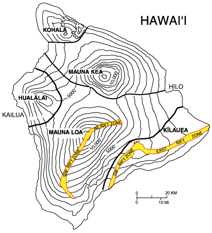
volcans, si proches et certes "frères de sang magmatique" 🌋🌋 aux altitudes quasiment identiques, sont différents par bien des aspects. Big Island, si "big" que son poids fait fléchir la croûte océanique jusqu'à plusieurs centaines de km, est constituée de
plusieurs volcans, les plus élevés étant le Mauna Kea (MK: 4207m) et le Mauna Loa (ML: 4169m). Mentionnons au passage les dates de leurs dernières éruptions au moment de cette sortie: -2500 pour le MK, 1984 pour le ML (cf. note de bas de page pour une petite mise à jour!). Le ML est plus massif (le cœur de Big Island, c'est lui) et représente l'archétype du volcan bouclier, couronné par une caldeira cyclopéenne (à l'instar de son cousin Martien,
Olympus Mons, encore plus colossal). De loin, ses pentes semblent régulières, modérées et lisses, alors que le MK est plus abrupt et irrégulier, hérissé d'un grand nombre de cônes secondaires (il serait dans une
phase éruptive plus tardive). De près, ils sont également différents: le ML semble formé par une accumulation de coulées de lave solidifiées, alors que le MK évoque plutôt un amoncellement monumental d'éjectas de tailles et de couleurs diverses, allant des cendres aux grosses bombes volcaniques. Même leurs roches semblent posséder des signatures compositionnelles assez distinctes (liées à un
panache mantellique bifide?). 🔥🔥 Bref, l'origine de ces différences semble donner du fil à retordre aux scientifiques, mais il n'y a pas que la montagne qui change: la
route aussi! Alors que la route du MK semble avoir été creusée de force pour gravir la montagne, qu'elle entaille avec un tracé brutal et impitoyablement pentu n'offrant pas le moindre répit, celle du ML, plus fine, ressemble à un ruban d'asphalte posé délicatement sur les champs de lave qui s'étendent à perte de vue, épousant les ondulations du paysage, ce qui donne l'impression d'évoluer sur des montagnes russes, 🎢 au gré des nombreuses petites descentes qui entrecoupent la montée! Les énormes aspérités de la lave nous donnent l'impression d'être tout petits, tout comme la majestueuse et imposante silhouette du MK, qui domine le paysage (quelques heures plus tôt, les rôles étaient inversés!). On se sent encore plus isolé du monde, dans ce paysage chaotique qui correspond à l'idée qu'on peut se faire de la Terre primitive...
Je n'osais pas, mais je me demande si ce n'est pas le moment d'évoquer mon idée de finir cette incroyable journée en trempant les roues sur une plage de l'autre côté de l'île, et Luke semble encore lire dans mes pensées: il anticipe ma requête et me demande ce que j'en pense... et comment, que ça me botte!!! 😄 Mais il faut d'abord en finir avec nos 28km d'ascension supplémentaires, pendant que le Mauna Kea accroche les derniers rayons du soleil. Au bout de ~14km, il y a une intersection en T à proximité de quelques antennes: une piste accompagnée d'une ligne électrique rejoint notre route, qui décrit un virage à angle droit vers l'Ouest. Ces poteaux électriques, très esthétiques dans le jour qui décline, vont désormais nous tenir compagnie jusqu'au bout. On retarde tant que possible l'allumage de nos lumières, d'une part pour les économiser, et d'autre part pour profiter du paysage sublime qui s'offre à nous, mais il faut bien finir par nous y résoudre. 💡 C'est long, très long, mais on perd un peu la notion du temps dans cette ambiance incroyable. Les étoiles commencent à scintiller les unes après les autres dans le ciel si pur. ✨ Luke reçoit un message de John: ils veulent venir voir ce que ça donne en voiture! On devrait donc avoir de la visite: reste à savoir qui arrivera en premier au bout de la route (eux ou nous?). Lors d'une petite pause, on éteint temporairement nos lumières, pour mieux apprécier le spectacle de la voûte céleste. Sur la fin, on repère quelques poignées de cailloux volcaniques bien tranchants sur la chaussée: il faudra y faire attention à la descente. Luke a clairement plus de jus que moi, mais il m'attend et on arrive finalement à la fin de l'asphalte, au niveau des
observatoires du Mauna Loa (3370m) (
solaire et
atmosphérique). On fait une petite photo (malheureusement de mauvaise qualité) devant les grilles. Précisons qu'il semble y avoir une sorte de "
piste hardcore" (dangereuse, même pour les 4x4) qui aboutit à proximité de la caldeira (peut-être même plusieurs variantes?), mais dont l'accès a été formellement interdit (je doute qu'elle soit vraiment cyclable, même avec un VTT ultra-robuste).
John et Clarence arrivent peu de temps après nous: ils nous félicitent, vérifient que nous ne manquons de rien, et commencent la descente avec nous. Je perds rapidement Luke de vue, concentré (à juste titre) sur ma route. Il faut dire qu'on prend facilement de la vitesse: je comprends pourquoi la fin a été dure! J'ai beau faire attention à ces maudits
cailloux repérés lors de la montée, ces infâmes salopards me surprennent sournoisement et j'en suis quitte pour une bonne frayeur en roulant dessus... je suis secoué, mais le vélo tient bien la route: ouf! 😳 Bien évidemment, je ralentis encore davantage la cadence et commence à me demander quand est-ce que je vais retrouver Luke, mais je n'ai pas beaucoup à attendre: j'aperçois les phares de la voiture, qui éclairent un vélo au sol. Nouvelle frayeur: aïe, Luke serait-il tombé?! 😨
Heureusement, il va bien! 😙 Il a toutefois roulé sur d'
autres cailloux, qui ont littéralement déchiqueté un de ses pneus. 😖 Damned... fin de parcours? 😬 Il en faut plus pour l'arrêter: pas question de laisser un vulgaire caillou mettre fin à cette journée mémorable, il va essayer de réparer ça. De nuit, à plus de 3000m d'altitude, pas évident de mettre une nouvelle chambre dans son pneu tubeless avec les doigts un peu gelés. 🥶 Il y a d'ailleurs plein de "jus de tubeless" qui dégouline sur la chaussée (on dirait du "sang de droïde", comme dans
Alien II). 😋 Cet arrêt imprévu prendra plus d'une heure, mais il persévère et parvient à ses fins: chapeau, le vélo est bon pour le service! 👍 John et Clarence repartent en voiture, et on voit leurs lumières s'évanouir lentement dans l'immensité du paysage. On distingue aussi les phares de quelques voitures qui descendent du voisin d'en face, le Mauna Kea. Au bout d'un moment, les lumières de Luke prennent aussi leurs distances, mais je trouve mon propre rythme. On peut sentir les ondulations de la route: il y a des petites montées!
Une fois à la Saddle road, direction plein Ouest: la route grimpe encore un petit peu (jusqu'à ~2060m), mais techniquement, elle ne passe pas au véritable col "inter-Mauna" (dénommé Humu'ula d'après la carte), qui se trouverait quelque part entre la nouvelle Saddle road et l'ancienne. Cette descente est irréelle, dans un état de concentration poussée. En tout, depuis les observatoires du Mauna Loa, ça nous fera presque 95km quasi-exclusivement en descente 😵 (les montées se feront assez rares). Par ailleurs, après les 28km de la route d'accès du Mauna Loa, il faut compter 38km sur la route 200, en prenant soin d'éviter l'immonde bande rugueuse (encore moins fréquentable à la descente qu'à la montée, comme on peut s'en douter). On roule souvent en parallèle sur la large bande d'arrêt d'urgence (j'entends le pantalon en lambeaux de Luke claquer au vent!) et parfois l'un derrière l'autre, ou plus exactement
Erwan derrière Luke... 🙃 occasionnellement réduit à un lointain point rouge clignotant, presque perdu dans la nuit, avant qu'il se laisse rattraper. 😉 Pour conclure en beauté, il nous faut notre 2e "dip", mais ce n'est pas évident de trouver un accès à une plage permettant de le faire! Je laisse Luke, qui connaît déjà Hawaï, me guider après la fin de la route 200: il a une idée en tête! Sur la fin, on tournicote un peu dans
Waikoloa beach 🌴 et on se faufile à travers un complexe hôtelier (bien entendu désert: il est environ 2h du mat') pour atteindre la plage d'Anaeho'omalu, où on peut tremper les roues (
double-dip!!!) 🤟 avant que Sam ne vienne nous récupérer en voiture! Une journée inoubliable... 😊
PS: Rien de monstrueux, mais je pense que le lissage de Wikiloc a enlevé un peu de dénivelé, notamment pour la route du Mauna Loa: elle "ondule" vraiment sur les coulées de lave et il y a pas mal de petites descentes (qu'on sent dans les pattes au retour!). Par ailleurs, ma route semble avoir été tellement "lissée" que le dénivelé positif est supérieur au dénivelé négatif... alors que la trace débute sur le parking de notre hôtel de Hilo et finit "les roues dans le Pacifique" (autrement dit, ça devrait être l'inverse!).
***
désactivation du mode "maniaque des traces GPS" *** 🔎 😇

🌋
Attention: quelques complications de dernière minute pour cet itinéraire! 🌋
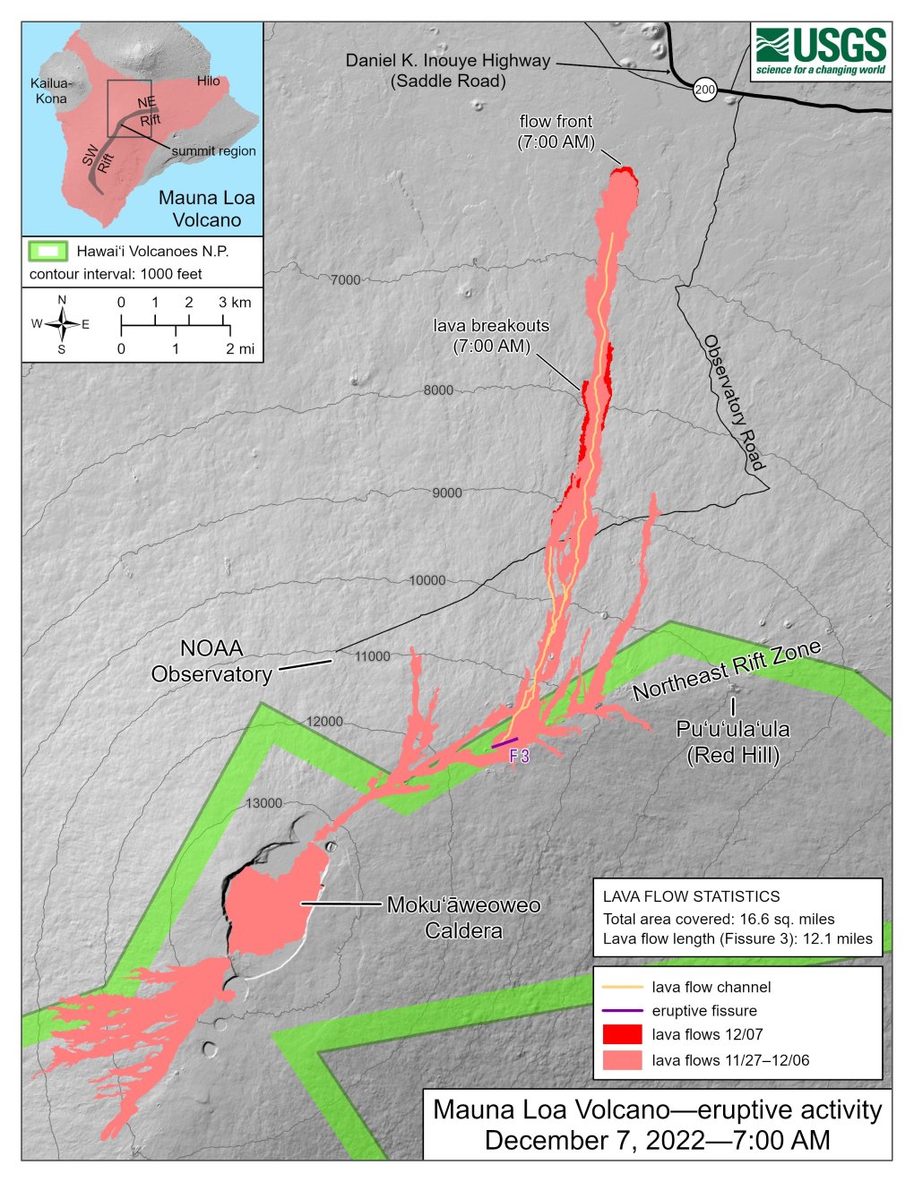
Au moment où j'écris ces lignes, fin 2022 (quelques mois après notre ascension), le Mauna Loa a décidé de se réveiller après une sieste de 38 ans. Cette éruption a produit des coulées de lave au Sud et au Nord de la caldeira principale, qui ont notamment coupé la route d'accès de l'observatoire en plusieurs endroits (ayons une pensée pour ces malheureux poteaux électriques, engloutis et carbonisés dans d'atroces souffrances) 🥺 et menacent carrément la Saddle road: prenez donc des pneus ignifugés au cas où... 😋
 Aventures hawaïennes à vélo
:
🚩 Hawaii 2022, 1/4: Mauna Kea & Mauna Loa
🚩
Hawaii 2022, 2/4: Chain of Craters road (Kīlauea) 🚩
Hawaii 2022, 3/4: Mauna Haleakalā 🚩
Hawaii 2022, 4/4: Waimea canyonAscent of Mauna Kea from Hilo, and Mauna Loa (to the observatory) in stride, before descending on the other side of the Big Island (Waikōloa beach) Made with Bob's gravel: part of the climb of Mauna Kea is on track, all the rest is asphalt Preamble : It's not yet daylight, 🌙 but it's the big day: we're at the foot of the beast! The day before, we left a car at the
Visitor Center with the spare bikes (for those who will be using a mountain bike on the track section), some supplies of water and food, clothes and other accessories. Get up before dawn, and leave at the foot of the huge
banyan tree in the parking lot of the Reeds Bay Hotel (the gigantic size of this tree seems to suggest that it appreciates the humid climate of Hilo, which is not necessarily the case of cyclists). Let's hope that my
Hispano -
Californian preparation will prove sufficient to tame the monumental Mauna Kea, the second summit of the globe in terms of "
dry prominence " (even if, I grant you, we will not start from the abyssal depths of the Pacific) . A thought for the only volcano that I have climbed so far, the
Puy de Dôme , before trying to move to the higher category! Today's peloton is made up of 5 cyclists: John, Clarence, Sam, Luke and myself (Chris and his wife will be waiting for us in the car at different places).
🏁 The idea is first to pedal to the "Mile 0" sign of the
Saddle road (Hawaii route 200) along the coast for 3km, before the sun emerges from the horizon, to take some group photos. Note in passing that I
exceptionally agree to use these Machiavellian and anachronistic imperial units, on the one hand because of the ease of conversion of zero mileage, and on the other hand out of respect for this symbolic sign. There is also a small beach of volcanic sand, at the foot of the modest
Coconut Point lighthouse , which allows us to symbolically dip a wheel in the ocean before really attacking the climb. Luckily, the sun peeks out between the clouds, 🌅 and the timing is perfect!
Let's go! A little nervous, I'm convinced I lost my glasses in the rush to leave... but in fact everything is fine. 😊 Clarence quickly leaves us company, in a hurry to fight the clock, but the rest of the troop prefers to play the card of caution, and stay more or less grouped together. We get back onto the main road after 17km: we will then drive for a good while on its wide emergency lane. Warning: everything is bigger in the USA, and the notches in the horrible rumble strip that separates us from the main roads are no exception, so deep that you will have to take care to avoid driving over them (we'll talk about that again!) . The first part of the ascent will be done in the rain, or rather in the drizzle (a "Hawaiian drizzle" ☔️ which explains the rather luxuriant vegetation), until we emerge above the clouds around 1000m above sea level. altitude (no surprise: John, who has already climbed this mountain several times, had warned us about the abundant rainfall on the windward coast), but the temperature remains pleasant. We will even have to take a break to apply cream, since the sun is climbing quickly in the sky and the altitude will not dampen the heat of its rays, knowing that there will be no shade to protect us 🌞 (despite the jersey, we will all burn a little at the shoulders: certain parts of the pretty jersey that John had made especially for the occasion were probably not sufficiently "UV-proof" for the high altitudes that await us! ). The vegetation gradually becomes more arid. We take our time (it's about saving our strength for the final part) to arrive at the level of Pu'u Huluhulu ("hairy hill" in Hawaiian), a bushy volcanic cone located at the foot of the access roads to the two large volcanoes.
Indeed, after 48km, barely a few hundred meters after ignoring the left fork (Mauna Loa road), we take the right fork, for Mauna Kea. There are still some traces of the recent
protests against the construction of the
TMT (Thirty Meter Telecope). It's from this
intersection of the Saddle road (2005m) that things will get seriously tough: the slope soon becomes steeper, it's sometimes even wickedly steep, but the landscape is worth it: on one side, we are overlooked by the steep peaks of Mauna Kea, and on the other, the imposing silhouette of Mauna Loa dominates the landscape (it seems almost smooth, seen from here, although the reality will be very different! ). A few trees here and there (even a small grove), but the scenery tends to become more mineralized little by little. 10km after leaving the Saddle road, we arrive at the
Visitor Center parking lot (2805m) , adjacent to the
Onizuka Center for International Astronomy , named in honor of El Onizuka, American astronaut of Japanese ancestry from the Big Island, who unfortunately passed away in the Challenger space shuttle explosion.
Food break, entry form submission (for the upper area of the volcano, in case of emergency) and pit stop for some: I keep the gravel for the entire ascent (a good compromise), but everyone the others change bikes, 🚲 preferring to opt for larger tires offering good grip in the volcanic ash. The part that awaits us will in fact be done on track (~8km): it is rather well packed (not much stone, only a few outcropping rocks), but the ash and the often severe slope do not really make the task easy. After a few hundred meters, I'm already starting to slip a lot. I then remember the advice I was given: deflate the tires a little... and it works! I really feel the difference: I will certainly have to dismount from time to time on a few short passages (too much slope and too much dust to have enough grip with my 38mm tires), but overall, in taking my trouble patiently, I'm not doing too badly! A very steep steep slope (where I find Luke) marks the
end of the track (3585m) ... and the return (appreciated!) of the asphalt.
Chris' car is waiting for us at this strategic point: Luke and the others will be able to pick up their road bikes for the last 6km stretch (which I will climb with Luke). If the surface improves, this is not the case for the slope which remains just as steep (sometimes we zigzag a little to reduce it!), not to mention that the air is rarefied: I realize that I I have never been at such a high altitude, whether on foot, by cable car or by bike (
Sierra Nevada ). However, I feel good, and I'm starting to consider trying the Mauna Loa in stride (to tell the truth, I had thought about it a few months before... before revising my ambitions downwards after having had a lot of drooling in the
Sierra de los Filabres last month, over significantly lower distances and elevations). Does Luke read my mind? 😮 He tells me that he plans to try this volcanic sequence! And when I ask him if I can accompany him, he doesn't mind the idea of having a little company. But let's not put the cart before the horse: the end is deserved, to say the least! After leaving on our right the small fork leading to the isolated antenna of the
Very Long Baseline Array , 📡 we take a last short break at the micro-parking lot which acts as a starting point for the path leading to the improbable
Lake Waiau , located at 3970m altitude (variable in size, but about 100m in diameter most of the time), unfortunately invisible from the road. We meet Clarence who is coming back down with a big smile, after having conquered the summit. One more last effort and a few ramps to reach the Astronomy Precinct of MKO (
Mauna Kea Observatories ) and the end of the
Mauna Kea road (4205m) , at the level of a first series of telescopes. The reward is worth the effort: what a view! Mauna Loa on one side, the rest of the telescopes on the other, with a micro-firn ❄️ in the foreground and a sea of clouds in the background, from which emerges another Hawaiian titan: 🌋 the Haleakalā, highest point on the neighboring island of Maui (which I hope to climb the
following week ). We take the time to savor before starting the descent...
We successively pass John and Sam on the way down, and we encourage them (but we feel that they will succeed!). I'm a little dreading the downhill section of the track: Luke, very comfortable on any type of bike, kindly offers me to do an exchange for this section: he takes my gravel and I take his mountain bike (with a fairly low, even for me). I obviously won't go as empty as him (I even lose sight of him), but reassured by the stability of the mountain bike, I still pick up quite a bit of speed and I won't have the feeling of skidding at any time despite the ashes. . On our return to the Visitor Center, no temperature control of the brakes, which nevertheless served well: the rangers reserve this for cars (during one of his previous visits, John had asked them to see what it was like for the discs of his bike!). 😅🌡️ A good hour of break time to hydrate and eat a little, to warn others of the rest of our adventures, and to take the necessary things in our bags: this additional adventure will be done by two people !
A bit of mist on the descent to the Saddle road: despite the anti-fog lenses, my visibility is reduced and I'm not going very fast. I meet Luke just before the intersection: he tells me that the weather forecast is not great on the Mauna Loa side, and that we will have to make a decision. He seems to have a moment of hesitation, look at my (disappointed?) expression 🥺 before quickly changing his mind:
“I had a moment of weakness” , he tells me! 😅 Anyway, here we go! We pass back in front of the Pu'u Huluhulu cone and attack Mauna Loa in a completely different atmosphere: we are directly in an almost purely mineral world, where vegetation is rare (a few rare shrubs manage to grow from time to time 🌱 on the flows, at least at the start of the route). And finally, there is not a fart of wind...
A word about the Mauna brosThese two
volcanoes , so close and certainly "magmatic blood brothers" 🌋🌋 at almost identical altitudes, are different in many ways. Big Island, so "big" that its weight causes the oceanic crust to bend up to several hundred km, is made up of
several volcanoes , the highest being Mauna Kea (MK: 4207m) and Mauna Loa (ML: 4169m) . Let us mention in passing the dates of their last eruptions at the time of this release: -2500 for the MK, 1984 for the ML (see footnote for a small update!). The ML is more massive (it is the heart of the Big Island) and represents the archetypal shield volcano, crowned by a cyclopean caldera (like its even more colossal Martian cousin,
Olympus Mons ). From a distance, its slopes appear regular, moderate and smooth, whereas the MK is steeper and more irregular, bristling with a large number of secondary cones (it would be in a
later eruptive phase ). Up close, they are also different: the ML appears to be formed by an accumulation of solidified lava flows, while the MK rather evokes a monumental pile of ejecta of various sizes and colors, ranging from ashes to large volcanic bombs. Even their rocks seem to have quite distinct compositional signatures (linked to a
bifid mantle plume ?). 🔥🔥 In short, the origin of these differences seems to give scientists a hard time, but it's not just the mountain that changes: the
road too! While the MK's road seems to have been forcibly dug to climb the mountain, which it cuts with a brutal and mercilessly steep route offering not the slightest respite, that of the ML, thinner, resembles a ribbon of asphalt delicately placed on the lava fields that stretch as far as the eye can see, marrying the undulations of the landscape, which gives the impression of evolving on a roller coaster, 🎢 according to the many small descents that intersect the climb! The huge asperities of the lava make us feel very small, as does the majestic and imposing silhouette of the MK, which dominates the landscape (a few hours earlier, the roles were reversed!). We feel even more isolated from the world, in this chaotic landscape which corresponds to the idea we can have of the primitive Earth...
I didn't dare, but I wonder if it's time to bring up my idea of ending this incredible day by dunking on a beach on the other side of the island, and Luke still seems to be reading in my thoughts: he anticipates my request and asks me what I think about it... and how, that really blows my mind!!! 😄 But first we have to finish our additional 28km of ascent, while Mauna Kea catches the last rays of the sun. After ~14km, there is a T-intersection near some antennas: a track accompanied by a power line joins our road, which makes a right angle turn towards the West. These electric poles, very aesthetic in the declining day, will now keep us company until the end. We delay turning on our lights as long as possible, on the one hand to save them, and on the other hand to enjoy the sublime landscape that is offered to us, but we have to end up doing it. 💡 It's long, very long, but we lose track of time in this incredible atmosphere. The stars begin to twinkle one after the other in the pure sky. ✨ Luke receives a message from John: they want to come and see what it looks like in the car! We should therefore have visitors: it remains to be seen who will arrive first at the end of the road (them or us?). During a short break, we temporarily turn off our lights, to better appreciate the spectacle of the celestial vault. At the end, we spot a few handfuls of very sharp volcanic stones on the road: you will have to be careful on the descent. Luke clearly has more juice than me, but he waits for me and we finally arrive at the end of the asphalt, at the level of
the Mauna Loa (3370m) observatories (
solar and
atmospheric ). We take a small photo (unfortunately of poor quality) in front of the gates. Let us point out that there seems to be a sort of "
hardcore track " (dangerous, even for 4x4s) which ends near the caldera (perhaps even several variations?), but access to which has been formally prohibited (I doubt it's really bikeable, even with a heavy-duty mountain bike).
John and Clarence arrive shortly after us: they congratulate us, check that we are not missing anything, and begin the descent with us. I quickly lose sight of Luke, focused (rightly) on my way. It must be said that we pick up speed easily: I understand why the end was hard! Although I pay attention to these damned
stones spotted during the climb, these infamous bastards sneakily surprise me and I get a good scare while riding on them... I'm shaken, but the bike holds up well: phew! 😳 Obviously, I slow down even more and start to wonder when I'm going to find Luke, but I don't have much to wait: I see the car's headlights, which illuminate a bike on the ground . New scare: ouch, has Luke fallen?! 😨
Fortunately, he is fine! 😙 However, he rolled over
other stones , which literally shredded one of his tires. 😖 Damned... end of course? 😬 It takes more to stop him: no question of letting a common stone end this memorable day, he will try to repair it. At night, at an altitude of more than 3000m, it's not easy to put a new tube in your tubeless tire with slightly frozen fingers. 🥶 There's also plenty of "tubeless juice" dripping on the road (it looks like "droid blood", like in
Alien II ). 😋 This unplanned stop will take more than an hour, but he perseveres and achieves his goals: hats off, the bike is good for service! 👍 John and Clarence leave by car, and we see their lights slowly fading in the immensity of the landscape. You can also make out the headlights of a few cars coming down from the opposite neighbor, Mauna Kea. After a while, Luke's lights also distance themselves, but I find my own rhythm. You can feel the undulations of the road: there are small climbs!
Once at the Saddle road, head due West: the road climbs a little bit more (up to ~2060m), but technically, it does not pass the real "inter-Mauna" pass (called Humu'ula after the map), which would be somewhere between the new Saddle road and the old one. This descent is unreal, in a state of high concentration. In all, from the Mauna Loa observatories, it will take us almost 95km almost exclusively downhill 😵 (the climbs will be quite rare). In addition, after the 28km of the Mauna Loa access road, it is necessary to count 38km on route 200, taking care to avoid the filthy rough strip (even less frequentable on the descent than on the ascent, as we can suspect it). We often ride in parallel on the wide hard shoulder (I hear Luke's ragged pants flapping in the wind!) and sometimes one behind the other, or more exactly
Erwan behind Luke ... 🙃 occasionally reduced to a distant flashing red dot, almost lost in the night, before it catches up. 😉 To conclude in style, we need our 2nd "dip", but it's not easy to find access to a beach to do it! I let Luke, who already knows Hawaii, guide me after the end of route 200: he has an idea in mind! At the end, we spin a little in
Waikoloa beach 🌴 and we sneak through a hotel complex (of course deserted: it's around 2 a.m.) to reach Anaeho'omalu beach, where we can soak the wheels (
double-dip!!! ) 🤟 before Sam comes to pick us up by car! An unforgettable day... 😊
PS: Nothing monstrous, but I think Wikiloc's smoothing removed a bit of elevation, especially for the Mauna Loa road: it really "undulates" on the lava flows and there are quite a few small descents (which 'we feel in our paws on the way back!). Moreover, my route seems to have been so "smoothed" that the positive elevation is greater than the negative... whereas the track begins in the parking lot of our hotel in Hilo and ends "the wheels in the Pacific" (in other words, it should be the other way around!).
***
deactivation of the "maniac GPS tracks" mode *** 🔎 😇
🌋
Attention: some last minute complications for this itinerary! 🌋
As I write this, in late 2022 (a few months after our ascent), Mauna Loa has decided to wake up after a 38-year nap. This eruption produced lava flows to the south and north of the main caldera, which notably cut the access road to the observatory in several places (let's spare a thought for these unfortunate electric poles, engulfed and charred in excruciating suffering) 🥺 and threaten the Saddle road: take fireproof tires just in case... 😋
Hawaiian Bike Adventures :
🚩 Hawaii 2022, 1/4: Mauna Kea & Mauna Loa
🚩
Hawaii 2022, 2/4: Chain of Craters road (Kīlauea) 🚩
Hawaii 2022, 3/4: Mauna Haleakalā🚩
Hawaii 2022, 4/4: Waimea canyon


Comments