
WCRVBB-21-ELBERADWEG - STAGE 04 - Hitzacker-Werben 101 km
Trail photos


Author

Trail stats
- Distance
- 62.46 mi
- Elevation gain
- 226 ft
- Technical difficulty
- Moderate
- Elevation loss
- 184 ft
- Max elevation
- 228 ft
- TrailRank
- 37
- Min elevation
- 43 ft
- Trail type
- One Way
- Coordinates
- 4862
- Uploaded
- October 6, 2013
- Recorded
- October 2013
near Marwedel, Niedersachsen (Deutschland)
Viewed 3268 times, downloaded 26 times
Trail photos
Itinerary description
| <<<Click for previous stage<<< | Click for entire route | >>>Click for next stage>>> |
| Click for the other WCRVBB routes | ||
WCRVBB-21-ELBERADWEG - STAGE 04 - Hitzacker-Werben 101 km
En la cuarta etapa de la ruta del Elba, se va de Hitzacker a Werben, abandonando ya la antigua RFA y entrando en la antigua RDA (actualmente Baja Sajonia y Sajonia Anhalt respectivamente). La primera parte discurre por la ruta oficial y en algunos puntos el track coge carreteras
secundarias debido a que nos encontramos lluvia.
La segunda parte, a partir de Wanzer, se discurre integramente por caminos cerca del río y de los diques, con vistas a mucha fauna ornitóloga y parajes preciosos del río, hasta llegar a la localida de Werben.
STAGE DESCRIPTION
After Hitzacker, we start the riding in paved paths near the river. At this point we find the first consequences of the Elbe floods of June 2013, with some roads in bad condicions of the pavement. But in general, all the trip has no signs of the floods.
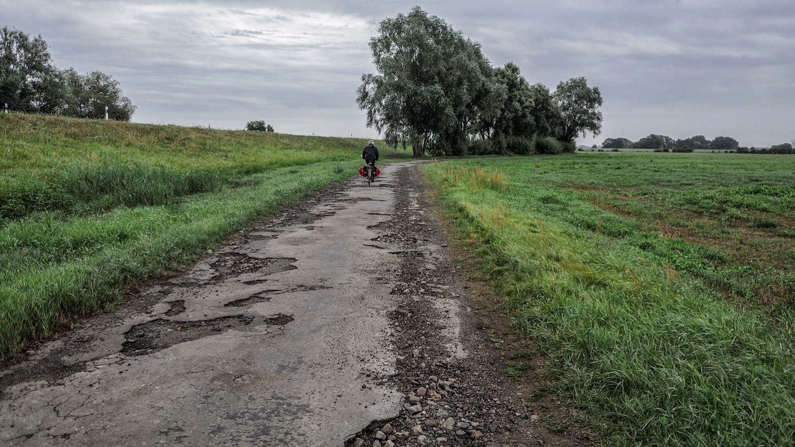
This first part of the stage is very flat and quite, in paved roads and some farm roads crossing the fields. Is interesting in this stages all the sort of different kind of cobbles and forms of the paths. Not allways is paved, but with many forms or shapes of cobbles. One of the examples
can be seen in next picture.

An interesting visit point is the unfinished bridge of Domitz, an old train bridge to cross the Elbe that was never finished due to lack of budget.

The path follows the river, but then we took some local roads due to the rain of that day. But we don't missed the most interestint part of the stage, that is the former border from West Germany and East Germany. In that point there is a monument with rests of the fence and some exhibitions.
There was the fact that in that point it used to be a village, Streesow, which was removed and translated to another place to form the frontier, a vast space with nobody.

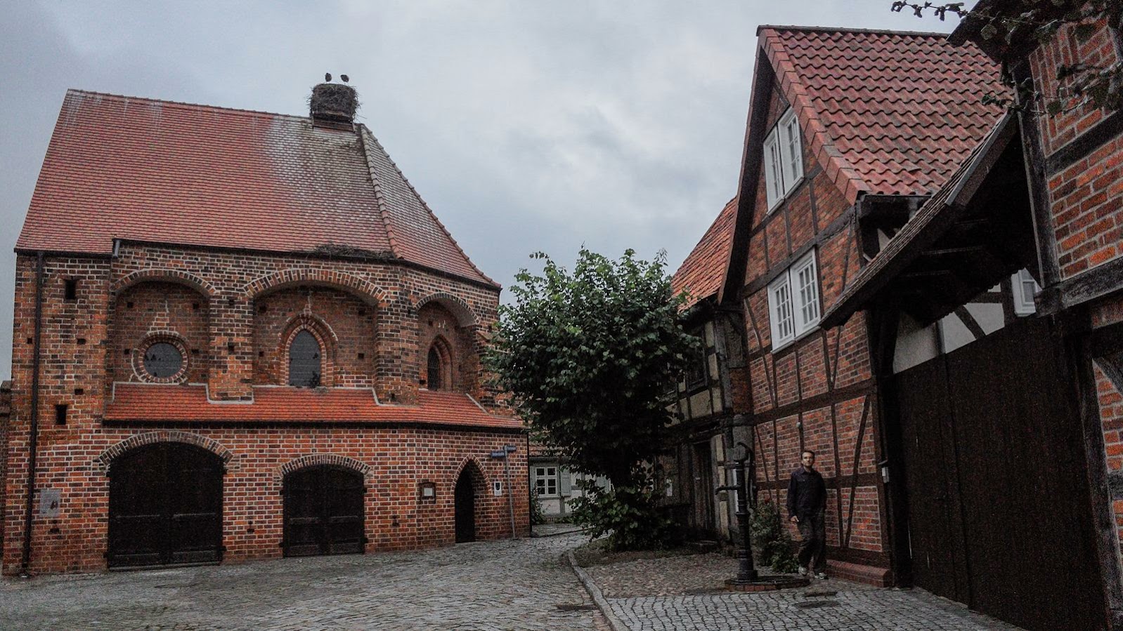
Some kilometers inside in former DDA you find the village of Wahrenberg, which has the curiosity of have many storks living in it. Many houses or sticks has stork nests, so you find people of the village proud of them. The paths goes on the dam, and there is a very charming place next to the church,
where you find a little bar to have a rest and take a delicious soup. There are no other places in that part of the stage to have something to eat.

The rest of the stage is very wild, solitary, with a paved path that goes through the marshes, the river and some fields. You can see many birds and there are no services of facilities till Werben, the final of the stage.
POINTS OF INTEREST
- Incomplete train bride of Dormitz.
- Some observation towers.
- Streesow memorial border (former border from DDA and RDA).
- Wahrenberg, the village of the storks.
DESTINATION POINT
Werben is a small village situated just behind the dam of the river. It has a very impressive brick church and an interesting tower with views over the river. There is also a building wich was used as a Salt storage place. The city is small so a good place to take a pacefull rest.
We stayed at Pension Rober, a familly small pension quite cheap and cozy.
ALTERNATIVE ROUTES
The route doesn't follow the official elberadweg in some parts, due to the rain we had (in the middle of the stage). In the first part and last part, you can take the main road, but it has no bike lanes and you miss much of the wonderfull and solitary paths near the river.
| <<<Click for previous stage<<< | Click for entire route | >>>Click for next stage>>> |
Podeu contactar amb vicens.borrell@gmail.com per mes informació.
You can contact with vicens.borrell@gmail.com for further information.
You can find the other world cycling routes of the WCRVBB project clicking here to access.
You can click over this other project bike routes or search the tags in google.
- DCRVBB, for one day routes around Europe.
- KCRVBB, for one day routes with kids around Europe.
- COLVBB, for climbings of Tour de France, Vuelta a Espanya, Giro di Italia, ...
- BCNVBB, for one day routes around Barcelona.
- RBTTCASSA, for MTB routes around Cassa de la Selva (Girona).
- RBTTCAT, for MTB routes around Catalunya.
Have a nice trip!

Waypoints
 Waypoint
 0 ft
0 ft
Memorial Border to Stresow village moved by frontier
Memorial Border to Stresow village moved by frontier
Waypoint
0 ft
Watch tower
Watch tower
Waypoint
0 ft
Watch Tower
Watch Tower
Waypoint
0 ft
Windmill
Windmill
Waypoint
0 ft
Hotel Werbe Pension Roter Adler
Waypoint
0 ft
Train Bridge incomplete of Doimuntz
Train Bridge incomplete of Doimuntz
Waypoint
0 ft
Point of View
Point of View
Waypoint
0 ft
Many Storks and signs
Many Storks and signs
Waypoint
0 ft
DDR Border Museum Fins les 17:00
DDR Border Museum Fins les 17:00
Waypoint
0 ft
Frontera RDA-RFA
Frontera RDA-RFA
Waypoint
0 ft
Elbe Tower
Elbe Tower
Waypoint
0 ft
Werbe Kirche
Werbe Kirche
Waypoint
0 ft
SalzKirche (Salt storage)
SalzKirche (Salt storage)
You can add a comment or review this trail
Comments