
Trail to River's End Motel Corner Brook 20 km
Author

Trail stats
- Distance
- 12.35 mi
- Elevation gain
- 1,076 ft
- Technical difficulty
- Moderate
- Elevation loss
- 1,467 ft
- Max elevation
- 941 ft
- TrailRank
- 1
- Min elevation
- 31 ft
- Trail type
- One Way
- Coordinates
- 132
- Uploaded
- April 30, 2019
- Recorded
- April 2019
near Hughes Brook, Newfoundland (Canada)
Viewed 72 times, downloaded 2 times
Itinerary description
Waypoints
 Waypoint
 52 ft
52 ft
Riverwood Cottages
http://riverwoodcottages.ca/
48.24067, -58.81157
Waypoint
37 ft
Cliffside Cabins
https://www.facebook.com/WendysCliffsideCottage/?fref=ts
They have two cabins. A big one and a smaller one.
Small cabin - 1 bedroom with a Queen bed, and a double pull-out sofa.
Large Cabin - 1 bedroom with King bed, a loft with a single bed and a double pull-out sofa.
48.2502, -58.817
Waypoint
12 ft
Esso Gas Station
48.76159, -54.22861
Waypoint
978 ft
Lookout Point

 Waypoint
79 ft
Waypoint
79 ft
Gas Station
Waypoint
146 ft
Tim Horton's
Waypoint
144 ft
Gas
Waypoint
3 ft
Esso Gas Station
49.22296, -55.05622
Waypoint
161 ft
Go straight here. Ignore the sign that says turn right.
Waypoint
44 ft
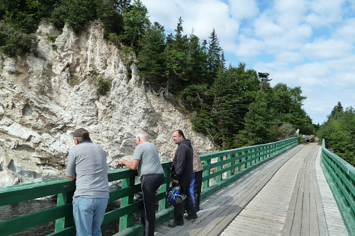
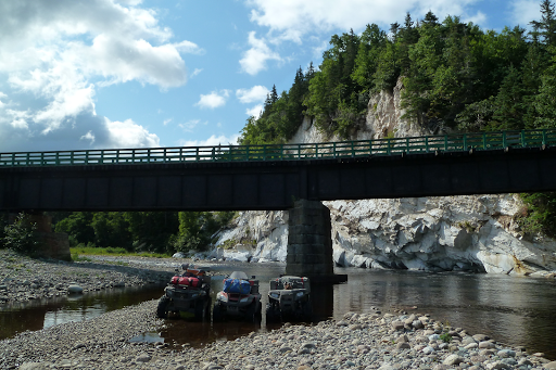
Fishell's Bridge
Nice spot to stop and take pictures of gypsum rock wall 48.30686, -58.67969
 Waypoint
121 ft
Waypoint
121 ft
Misty River Cottages
https://www.facebook.com/mistyrivercottages/?ref=py_c
48.99216, -54.87456
709-679-5799
Waypoint
263 ft
Hotel Robin Hood
48.93533, -55.66226
http://www.hotelrobinhood.com/
Waypoint
339 ft
Clarenville Car Care (CF MOTO Dealer)
48.16678, -53.98873
http://clarenvillecarcare.com/
Waypoint
259 ft
Marsh Motor Sports (Can Am & Cf Moto)
48.94738, -55.6553
https://www.marshmotorsports.ca/
Waypoint
262 ft
Beothuck Campground - ATV Friendly
They have showers, and a laundry facility.
Waypoint
555 ft
Abandoned Campground Stag Lake
Waypoint
115 ft
David Smallwood Campground
1 709-674-0122
Showers, Laundry. Store nearby.
48.80446, -54.21939
Waypoint
99 ft
Johnny's One Stop - Gas, Liquor, Convenience Store
This is a modern, clean one stop shop.
Waypoint
238 ft
Gas Station
Waypoint
150 ft
Restland Motel
Waypoint
94 ft
Underground Turret
Will need Flashlight
Waypoint
68 ft
Old Military Building
Waypoint
56 ft
Old Military Building
Waypoint
149 ft
Trail to old underground military hospital
go around the rocks to get to it
Waypoint
40 ft
Rapid Power Sports
Can Am and Kawasaki Dealer
You can add a comment or review this trail
Comments