
Clarenville to Gander - from Crossing NL By ATV
Author

Trail stats
- Distance
- 86.96 mi
- Elevation gain
- 2,142 ft
- Technical difficulty
- Easy
- Elevation loss
- 2,001 ft
- Max elevation
- 539 ft
- TrailRank
- 23
- Min elevation
- 539 ft
- Trail type
- One Way
- Coordinates
- 269
- Uploaded
- May 31, 2020
- Recorded
- May 2020
near Clarenville, Newfoundland (Canada)
Viewed 1124 times, downloaded 28 times
Itinerary description
This trail takes you from Clarenville to Gander (approx 145 km). It shows you beautiful rest and photo spots, gas stations, food etc. From my 2018 ATV Trip across Newfoundland. From east to west. Mostly easy with a few moderate sections.
If you want to do the Cross NL By ATV read these websites. Everything you need to know is there.
http://www.CrossingNewfoundlandByATV.com
http://www.Facebook.com/CrossingNewfoundlandByATV
http://www.YouTube.com/EastCoastATV
If you want to do the Cross NL By ATV read these websites. Everything you need to know is there.
http://www.CrossingNewfoundlandByATV.com
http://www.Facebook.com/CrossingNewfoundlandByATV
http://www.YouTube.com/EastCoastATV
Waypoints
 Waypoint
 449 ft
ADVENTURE Sales - POLARIS Dealer
48.95259, -54.59587
Waypoint
406 ft
Comfort Inn Gander
This isn't a far ride from the trail. There are are restaurants close by and I think breakfast is included with the cost of the room. They have rooms that you can ride your atv up to and park next to the door. There are a few Motels on this stretch of road.
48.95163, -54.61916
Waypoint
325 ft
Country Inn Hotel and RV Park
You can tent here instead of Motel if you like
48.98508, -54.60701
http://www.countryinngander.ca/
Waypoint
16 ft
Esso Gas Station2
48.67234, -54.02672
Waypoint
406 ft
Esso Gas Station3
48.96127, -54.5963
Waypoint
12 ft
Esso Gas Station4
48.76159, -54.22861
Waypoint
430 ft
Gas Station14
Waypoint
119 ft
Gas Station5
Waypoint
194 ft
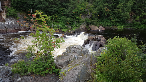
Picnic Spot
This is a beautiful spot overlooking a nice waterfall
 Waypoint
426 ft
Waypoint
426 ft
Rosie's Restaurant
Great Food!
Waypoint
453 ft
Simmons Honda ATV Dealer
Waypoint
73 ft
St. Jude Hotel1
Waypoint
0 ft
Trailway Pub
48.76469, -54.22469
Waypoint
427 ft
WalMart
Waypoint
98 ft
Waterfalls
There are 3 waterfalls here if you don't mind hiking to see them all.
You can add a comment or review this trail
Comments